Saxon milepost
The Saxon head postal director (Oberpostdirektor), Paul Vermehren, brought about their inception based on official distance surveys, whose results were given in leagues on the post mileposts.
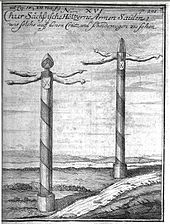
These consisted of a wooden post, at the upper end of which were direction indicators in the shape of human arms and hands.
Because the wood rotted rapidly as a result of its constant exposure to moisture, many of these fingerposts collapsed a few years after they had been erected and became unusable.
Similar posts or stones with distances marked on them were erected along the roads in a number of countries.
The basis for the introduction of Saxon mileposts was the cartographic work of the pastor, Adam Friedrich Zürner, from Skassa.
After further cartographic work, the prince elector gave him the task on 12 April 1713 of: "recording districts, including the lordships, manor estates, towns, villages and the like, on geographic maps" (original: "Aemter samt denen darinnen befindlichen Herrschaften, Rittergütern, Städten, Dörfern und dergleichen mehr in mappas geographicas bringen").
The prince elector only had an improved postal map published which was the result of an extension to the contract that followed a few weeks later.
Zürner's assistants used a measuring cart in the shape of a wheelbarrow for those tracks unsuitable for a coach, which likewise measured the distances by the turning of a wheel and which was carried as the so-called "fifth wheel on the wagon" (fünftes Rad am Wagen) in a case on the surveying coach.
During such a journey, the assistant to the surveyor had to drive a numbered wooden stake into the ground every quarter of a mile and dig a hole next to it.
On 19 September 1721, an Electoral order was issued to the districts (Ämter) of Dresden, Meißen and Großenhain, to erect stone columns as mileposts.
On the same day the state authorities in charge issued the general ordinance for the "Establishment of Stone Postal Columns" (Setzung der steinernen Post-Säulen) and the instruction that the costs of erecting them were to be borne by the landowner of the locations affected.
Zürner set forth that a large distance column (Distanzsäule) was to be erected immediately in front of the gates of a town.
Today the Saxon section of the Old Dresden to Teplitz Post Road is considered the historic transport link with the most surviving postal mileposts.
Because the means of the towns varied considerably depending on their size and industrial structure, the financial impact on them was very variable.
In 1722, the Saxon Landtag asked the prince elector to cancel the expensive project that had invoked the opposition of many town councils and landowners.
[4] In order to enforce the implementation of his instructions, the elector had resort to harsh measures and threatened negligence, tardiness or damage to the mileposts with disciplinary action in an order of 24 July 1722; and in another edict of 7 September 1724, fines of 20 talers were imposed against every official guilty of missing deadlines and in each individual case of neglect.
[7] As the order dated 19 September 1721 incorporated a comprehensive memorandum of 24 items and was accompanied by a list of the benefits of the regulation, it appears that problems had been anticipated from the outset.
[10] Due to persistent opposition the Saxon Landtage was finally able to issue a decree on 12 April 1728 that - contrary to the Elector's wishes - the mileposts need only be erected on main and postal roads.
Their final appearance, which was based on baroque and classical prototypes, was linked to the senior state architect (Oberlandesbaumeister), Matthäus Daniel Pöppelmann.
The column consists of the base (Zwischenplatte or Schaftfuß), the shaft, a block sowing the coat of arms (Wappenstück), and the finial (Aufsatz or Spitze).
On the shaft of the column the names of the destinations were inscribed at Zürner's direction in a Fraktur font and based on the distance tables that had been worked out for each town.
The quarter mile stone (Viertelmeilenstein) rests on a low pedestal and consists of a rectangular column or stele.
Preparations for the introduction of the metric system in the Kingdom of Saxony were made as part of the work of the Standardization Commission (Normalaichungscommission), led by Albert Christian Weinlig and Julius Ambrosius Hülße.
Upon the full introduction of the metric system around 1900, some of these were converted to kilometer, chaussee, boundary (Flurgrenz) and roadkeeper stones (Straßenwärtersteine).