Schoharie Crossing State Historic Site
Located at the south east corner of the confluence of the Mohawk River and Schoharie Creek was the Native American fortified village of Tiononderoge.
[3] Europeans called the village the Lower Castle from its position as the major eastern settlement (furthest downstream) of the Mohawk.
The Mohawk offered help in settling Palatine German refugees in New York, who had arrived that year and were working in English camps along the Hudson River.
During one of the raids, a group of men retrieved Queen Anne's gifts, which had been buried at Fort Hunter.
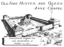
After the American Revolutionary War, Queen Anne's Chapel was used for a time as a tavern and stable, to house the many migrants at Fort Hunter, which had developed into a village.
In 1957 and 1958 a group of Mohawks from Kanawake set up an encampment at Schorarie Creek after being displaced by the St. Lawrence Seaway project.
The canal originally crossed through the creek in a slack water pool that was created by a log and stone dam.
Fourteen arches spanning 624 feet carried the Enlarged Erie Canal and towpath across the Schoharie Creek from 1845 until 1916.
In the 1940s, the Army Corps of Engineers demolished the easternmost six arches of the aqueduct to alleviate ice jams.
The Schoharie Crossing State Historic Site includes many other remnants of the Enlarged Erie Canal.
[7] "Yankee Hill" Lock 28 and Putman's Canal Store are located off of Queen Anne Street.
The Visitor Center - which opened in 1987 - is located at 129 Schoharie Street in Fort Hunter, Montgomery County, New York.
During the flooding caused by Hurricane Irene in 2011, the parking lot was washed away, revealing the foundation for the mid-18th century Fort Hunter.
It brings visitors through the progression of the canal system in New York from concept to construction and on to modern usage.
A boat launch and picnic area are located at the end of Dufel Road on the west side of the Schoharie Creek.