Wallkill Valley Rail Trail
The Wallkill Valley Land Trust, in partnership with Open Space Institute, acquired the additional property from Ulster County and began several capital campaigns to open-up public access.
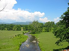
Several natural features are visible from clear points along the trail, such as the Shawangunk Ridge to the west and the Plattekill Creek between New Paltz and Gardiner.
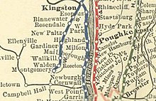
Stretching 33 miles (53 km)[6] from Montgomery to Kingston,[7] the Wallkill Valley Railroad operated from 1866[8] until its last regular freight run on December 31, 1977.
[22] The study considered repurposing the corridor as a road for cars, but determined that the right-of-way, "lend[ing] itself to multiple and simultaneous 'people-oriented' transit", was "ideally suited for use as a trail for hiking, strolling, running, cycling and cross-country skiing".
[24] While the town and village of New Paltz immediately purchased their sections from the Wallkill Valley Land Trust, with conservation easements on them – roughly 4 and 3 miles (6.4 and 4.8 km), respectively[25] – Gardiner did not purchase its 6-mile (9.7 km) section until much later; again, at that time, the Wallkill Valley Land Trust stewards held the conservation easements.
[29] Gardiner received a $100,000 grant from the New York State Office of Parks, Recreation and Historic Preservation in December 2006,[30] and the purchase was completed in 2007.
[31] Purchasing the section allowed Gardiner to fix the drainage problems that had deteriorated the surface of the trail and to ban the use of motor vehicles.
[32] In November 2009, New Paltz received grants from the Greenway Conservancy, a state organization, to fund several rail trail–related projects.
[33] The town had intended to connect the parking area with the trail since the late 1990s, but concerns over traffic, as well as state requirements, had added to the time and cost of the path; it was completed by June, 2010.
[37][38] The connections are part of a county-wide plan to create a bicycle path along NY 299, to link regional rail trails.
[42] Conrail sold the Rosendale section, including the bridge, in 1986 to a private area businessman, John E. Rahl, for one dollar.
Rahl maintained that the purchase granted him the right to "restore rail service on the whole Wallkill line",[25] and to joint ownership of Conrail.
[28] He intended to allow bungee jumping off the bridge,[25][39] and did so until a January, 1992 court order held that it violated zoning laws.
[45][46] Douglas Hase, an entrepreneur who had run both bungee jumping and hot air ballooning companies,[47] tried unsuccessfully in 2003 and 2004 to get a variance for such a venture.
The Wallkill Valley Land Trust and Open Space Institute placed a bid on the land parcels comprising the Rosendale section on April 22, 2009,[49] and agreed to pay all outstanding taxes before receiving full ownership on July 8, 2009,[50] with the intention of adding it to the Wallkill Valley Rail Trail.
[57] The Mohonk Preserve and Open Space Conservancy were given a $20,000 state grant in March 2011, to maintain the portion of the trail by Kingston.
[63] Built in 1881[64] and opened the following year, the creamery was one of the dairies that transported its products to New York City by way of the Wallkill Valley Railroad.
After another 1⁄2 mile (0.80 km) the trail traverses Huguenot Street,[76] a historic district containing colonial-era stone houses.
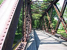
[85] About 1 mile (1.6 km) from Huguenot Street, the trail reaches the 413-foot (126 m) Springtown bridge spanning the Wallkill River.
[86] The bridge was originally made of wood and completed by the middle of December 1870,[73][87] but was rebuilt between 1880 and 1881, using iron, by Clarke, Reeves & Co.[88] It was rated by the superintendent of the Wallkill Valley Railroad to be safe for rail traffic as fast as 40 miles per hour (64 km/h).
[89] The bridge's decking and benches were put in place in 1993 by volunteers and members of the nearby Hutterite community in the hamlet of Rifton.
[92] This added 11+1⁄2 miles (18.5 km) over the Rondout Creek to Kingston,[53] crossing Interstate 87 and terminating by State Route 32.
The road between the former railroad station and Water Street Market was the first site of a new town crosswalk system that opened on March 29, 2008.
[96] The trail connects with the Sojourner Truth park, which has had access to the Wallkill River for kayaking and canoeing since April 27, 2003.
The district was the location of several local quarries which opened throughout the region after the 1825 discovery of rocks capable of producing Rosendale cement in the nearby hamlet of High Falls.
The district was the location of several local quarries which opened throughout the region after the 1825 discovery of rocks capable of producing Rosendale cement in the nearby hamlet of High Falls.
As the trail approaches Gardiner to the south, there are occurrences of sugar maple (Acer saccharum), American beech (Fagus grandifolia), tulip-tree (Liriodendron tulipifera) and black birch (Betula lenta).
[75] Other trees common on the trail include red maple (Acer rubrum), shagbark hickory (Carya ovata), northern pin oak (Quercus ellipsoidalis), eastern red cedar (Juniperus virginiana), white ash (Fraxinus americana) and eastern white pine (Pinus strobus).
[116] Several bird species overwinter in the region and can be observed from the trail, such as the mourning dove (Zenaida macroura), blue jay (Cyanocitta cristata), bluebird (Sialia), cardinal (Cardinalis cardinalis), starling (Sturnus vulgaris), downy woodpecker (Picoides pubescens), American goldfinch (Spinus tristis), tufted titmouse (Baeolophus bicolor), black-capped chickadee (Poecile atricapillus), sparrow (Passer) and purple finch (Carpodacus purpureus).
[117] The Springtown Truss Bridge was used as a location for key scenes in the John Krasinski horror film A Quiet Place, as well as its sequel.