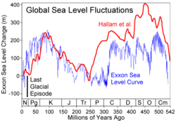
Sea-level curve
The names of the curve refer to the fact that in 1977 a team of Exxon geologists from Esso Production Research headed by Peter Vail published a monograph[1] on seismic stratigraphic principles and global (eustati)) sea-level changes.
Their sea-level curve was based on seismic and biostratigraphic data accumulated during petroleum exploration.
[2] The Vail curve (and the monograph itself) was the subject of debate among geologists, because it was based on undisclosed commercially confidential stratigraphic data, and hence not independently verifiable.
[3] Because of this, there were later efforts to establish a sea-level curve based on non-commercial, public domain data from outcrops exposed on land and thus verifiable by other reserchers.
Subsequent revisions of the Mesozoic eustatic sea-level curve have been published by Haq for the Cretaceous, Jurassic, and Triassic, respectively in 2014, 2017, and 2018.