Sea of Japan naming dispute
A dispute exists over the international name for the body of water which is bordered by Japan, Korea (North and South) and Russia.
[2][3][4][5] The involved countries (especially Japan and South Korea) have advanced a variety of arguments to support their preferred name(s).
Additional arguments have been raised regarding the underlying geography of the sea as well as potential problems regarding the ambiguity of one name or the other.
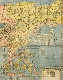
According to South Korea's Ministry of Foreign Affairs, the name East Sea (Donghae(동해)) can be found in various historical records produced in the span of over 2,000 years, including the History of the Three Kingdoms (1145),[7] the monument of King Gwanggaeto (414), and "Map of Eight Provinces of Korea" (八道總圖, 1530).
[10] Moreover, South Korea argues that it was unable to present its case for the name 'East Sea' internationally because it was under Japan's colonial rule and in the midst of the Korean War.
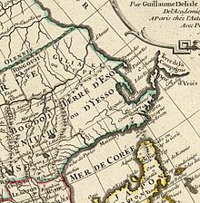
[12] The Japanese government claims that the name Sea of Japan had been internationally used since the 17th century and established by the early 19th century, during which Japan was under an isolationist policy (Sakoku) of the Tokugawa shogunate that restricted cultural exchange and commerce with foreign countries except China and the Netherlands until 1854.
[14] The invention of the marine chronometer in the late 18th century enabled Western explorers, such as Jean-François de Galaup from France, William Robert Broughton from Britain, and Adam Johann von Krusenstern (Ivan Fyodorovich Kruzenshtern) from Russia, to measure time and longitudes on the sea precisely and map the detailed shape of the Sea of Japan.
[15] According to Japanese records, it was Krusenstern who popularized the name "Mer du Japon" (Sea of Japan) in the West.
"[14] The original book was published in St. Petersburg in German and Russian, translated into Dutch, French, Swedish, Italian, and English, and distributed widely among Europe.
The English Channel/La Manche, which is referred to in the IHO Resolution 1/1972 as an example of concurrent usage, is composed of only the territorial seas and the exclusive economic zones of the UK and France.
The East Sea/Sea of Japan is also composed of only territorial seas and exclusive economic zones of its coastal states, which is no different from the case of English Channel/La Manche.
[citation needed] At the 2nd Session of the Assembly in 2020, the member states decided to replace the sea area names in S-23 with unique numerical identifiers and to develop a new digital standard (S-130) that meets the requirements of contemporary geographic information systems.
[29] While the United Nations has never directly addressed the issue of establishing an official, standardized name for the sea, several resolutions and statements by the UN have had relevance to the topic.
The Japanese representative stated that the name of the Sea of Japan had already been accepted worldwide and that any change would introduce confusion.
Japan, however, opposed the method by which the South Korean government proposed the issue, arguing that they had not followed the proper procedure for doing so.
Following some debate, South Korea withdrew the issue, and instead recommended that the United Nations Group of Experts on Geographical Names work so that a resolution could be submitted to the Eighth UNSCGN conference.
[32] At the Eighth UNCSGN in 2002, South Korea and Japan presented a number of papers to the conference regarding their positions on the naming issue.
In a letter to South Korea, it was explained that the UN was not determining the validity of either name, but wished to use the term that is most widely used until the parties resolved the disagreement.
Ferjan Ormeling Jr., chairman of the conference, responded that the organization had no authority to decide the issue and requested that the involved countries resolve the differences over the name amongst themselves.
[39][40] Japan believes that Russia played a major role in establishing this name internationally, as mentioned above.
[1] The United States Board on Geographic Names (BGN) continues to advocate the use of Sea of Japan without qualification in U.S. government publications.
11, was finally passed by the Virginia House of Delegates on 6 February 2014, signed by the Governor on 28 March and became effective on 1 July.
This policy applies to all seas, including those bordered by multiple countries that may each have their own names for such bodies of water.
Concerning the body of water between the Japanese archipelago and the Korean Peninsula, longstanding U.S. policy is to refer to it as the "Sea of Japan".
"[50][51] Contrary to the position of a few major countries, a number of maps, encyclopedias, and other publications have switched to using both names.

Japan's preference: Sea of Japan
North Korea's preference: Korean East Sea
South Korea's preference: East Sea