Seismic magnitude scales
[2] The intensity of local ground-shaking depends on several factors besides the magnitude of the earthquake,[3] one of the most important being soil conditions.
For instance, thick layers of soft soil (such as fill) can amplify seismic waves, often at a considerable distance from the source, while sedimentary basins will often resonate, increasing the duration of shaking.
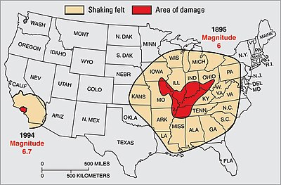
This is why, in the 1989 Loma Prieta earthquake, the Marina district of San Francisco was one of the most damaged areas, though it was nearly 100 km from the epicenter.
All "Local" (ML) magnitudes are based on the maximum amplitude of the ground shaking, without distinguishing the different seismic waves.
They underestimate the strength: The original "Richter" scale, developed in the geological context of Southern California and Nevada, was later found to be inaccurate for earthquakes in the central and eastern parts of the North American continent (everywhere east of the Rocky Mountains) because of differences in the continental crust.
[29] It was introduced in the 1960s with the establishment of the World-Wide Standardized Seismograph Network (WWSSN); the short period improves detection of smaller events, and better discriminates between tectonic earthquakes and underground nuclear explosions.
The ML scale was developed in southern California, which lies on blocks of oceanic crust, typically basalt or sedimentary rock, which have been accreted to the continent.
In this area the ML scale gives anomalous results for earthquakes that by other measures seemed equivalent to quakes in California.
[43] A "broad-band" variant (Ms_BB, Ms(BB)) measures the largest velocity amplitude in the Rayleigh-wave train for periods up to 60 seconds.
The moment magnitude scale – Mw or Mw – developed by seismologists Thomas C. Hanks and Hiroo Kanamori,[47] is based on an earthquake's seismic moment, M0, a measure of how much work an earthquake does in sliding one patch of rock past another patch of rock.
These factors can be estimated for an existing fault to determine the magnitude of past earthquakes, or what might be anticipated for the future.
[50] However, it is based on a simple model of rupture, and on certain simplifying assumptions; it does not account for the fact that the proportion of energy radiated as seismic waves varies among earthquakes.
[53] The proportion of total energy radiated as seismic waves varies greatly depending on focal mechanism and tectonic environment;[54] Me and Mw for very similar earthquakes can differ by as much as 1.4 units.
In October a Mw 7.1 quake in nearly the same location, but twice as deep and on a different kind of fault, was felt over a broad area, injured over 300 people, and destroyed or seriously damaged over 10,000 houses.
K (from the Russian word класс, 'class', in the sense of a category[57]) is a measure of earthquake magnitude in the energy class or K-class system, developed in 1955 by Soviet seismologists in the remote Garm (Tajikistan) region of Central Asia; in revised form it is still used for local and regional quakes in many states formerly aligned with the Soviet Union (including Cuba).
Based on seismic energy (K = log ES, in Joules), difficulty in implementing it using the technology of the time led to revisions in 1958 and 1960.
Any skew in the spectral distribution can result in larger, or smaller, tsunamis than expected for a nominal magnitude.
[65] This is based on Rayleigh waves that penetrate into the Earth's mantle, and can be determined quickly, and without complete knowledge of other parameters such as the earthquake's depth.
Md designates various scales that estimate magnitude from the duration or length of some part of the seismic wave-train.
[67] For short distances (less than ~100 km) these can provide a quick estimate of magnitude before the quake's exact location is known.
Magnitude scales generally are based on instrumental measurement of some aspect of the seismic wave as recorded on a seismogram.
Where such records do not exist, magnitudes can be estimated from reports of the macroseismic events such as described by intensity scales.
[69] One approach for doing this (developed by Beno Gutenberg and Charles Richter in 1942[70]) relates the maximum intensity observed (presumably this is over the epicenter), denoted I0 (capital I with a subscripted zero), to the magnitude.
[73] A variant, MLa, adapted to California and Hawaii, derives the local magnitude (ML) from the size of the area affected by a given intensity.
[76] In Japan, a network of strong-motion accelerometers provides PGA data that permits site-specific correlation with different magnitude earthquakes.
This correlation can be inverted to estimate the ground shaking at that site due to an earthquake of a given magnitude at a given distance.
The Southern California Seismic Network uses this "magnitude" where the data fail the quality criteria.
[80] Consequently, while some catalogs identify these magnitudes as MGR, others use UK (meaning "computational method unknown").