September 1921 San Antonio floods
In early September 1921, the remnants of a category 1 hurricane brought damaging floods to areas of Mexico and the U.S. state of Texas, particularly in the San Antonio region.
Moving slowly in a general westward direction, the disturbance reached hurricane intensity on September 7 prior to making landfall south of Tampico, Mexico the following day.
Similarly, an observation of 36.40 in (925 mm) elsewhere in Williamson County, Texas ranked as the sixth-highest tropical cyclone-related rainfall total for the state.
The high precipitation totals set nationwide records which would stand for several years.The loss in money was 19 million in 1921 USD.
[2] Its lack of organization resulted in its estimated misplacement inland over Mexico in the Signal Corps's weather map for September 5.
[1] Despite the analyzed intensification, the updated Signal Corps weather maps for the tropical cyclone that day indicated that the system had degenerated back into an open trough.
Just prior to landfall at 0100 UTC, a ship had reported winds of 80 mph (130 km/h) from the southeast and a pressure of 996 mbar (hPa; 29.42 inHg).
In addition, a separate tropical cyclone located near Barbados was able to alter the positioning of isobars over the area, such that heavy rainfall would result.
[7] Due to the rapid accumulation of floodwaters, the United States Weather Bureau issued numerous flood warnings.
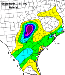
[7] Though peak rainfall estimates have been widely disputed,[7][9][11] it has been most recently estimated that the peak precipitation amount in Texas associated with the storm to have been a recording of 40 in (1016 mm) in Thrall over a three-day period; this would make the storm the fourth wettest tropical cyclone to impact Texas since record keeping began.
[10] Similarly, another location in Williamson County reported 36.40 in (925 mm) of rain in 18 hours, which would be a national record for most rainfall in its respective period.
In nearby Thorndale, rains estimated as high as 25 in (635 mm) caused streams to overflow, reaching levels unseen since the 1900 Galveston hurricane.
Since rainfall was mostly concentrated upstream of the mouth of the Rio Grande, the resulting river rises caused a wave of high water which pushed downstream.
[7] Overall, the floods associated with the remnant tropical cyclone caused $19 million in property losses, particularly in the counties of Bell, Bexar, Milam, Travis, and Williamson.

Tropical storm (39–73 mph, 63–118 km/h)
Category 1 (74–95 mph, 119–153 km/h)
Category 2 (96–110 mph, 154–177 km/h)
Category 3 (111–129 mph, 178–208 km/h)
Category 4 (130–156 mph, 209–251 km/h)
Category 5 (≥157 mph, ≥252 km/h)
Unknown