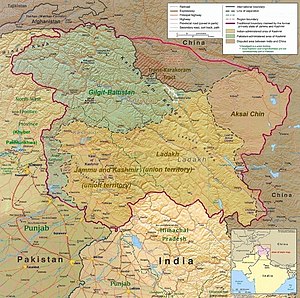
Trans-Karakoram Tract
[13] The MacDonald line was modified in 1905 to include in India a small area east of the Shimshal Pass, to put the border on a stretch of the Shaksgam River.
[14] At the same time, in view of "The Great Game", Britain was concerned at the danger of Russian expansion as Qing dynasty China weakened and so adopted a policy of claiming a border north of the Shaksgam River.
[16] The Gazetteer of Kashmír and Ladákh, first published in 1890 and compiled under the direction of the Quarter Master General in India in the Intelligence Branch, gives a description and details of places inside Kashmir.
The Gazetteer states in pages 520 and 364 that “The eastern (Kuenlun) range forms the southern boundary of Khotan”, “and is crossed by two passes, the Yangi or Elchi Diwan, .... and the Hindutak (i.e. Híñdutásh ) Díwán”.
[20] Since 1947, India has claimed sovereignty over the entire area of the pre-1947 independent state of Jammu and Kashmir and maintains that Pakistan and China do not share a common border.
The northern border published by the 1954 Times Atlas more or less followed the watershed of the Kuen Lun range from the Taghdumbash Pamir to the Yangi Dawan pass north of Kulanaldi, but east of the Yangi Dawan Pass, the border deviated from the watershed of the Kuen Lun range on the edge of the highlands of Kashmir.
After Pakistan voted to grant China a seat in the United Nations, the Chinese withdrew the disputed maps in January 1962, agreeing to enter border talks in March.
Negotiations between the nations officially began on October 13, 1962, and resulted in the Sino-Pakistan Agreement signed on 2 March 1963 by foreign ministers Chen Yi of China and Zulfikar Ali Bhutto of Pakistan.
In the opinion of Jawaharlal Nehru, "According to the survey of Pakistan maps, even those published in 1962, about 11,000 square miles [28,000 km2] of Sinkiang territory formed part of Kashmir.