Al-Shaykh Maskin
Nearby localities include Ibta' and Da'el to the south, Khirbet al-Ghazaleh the southeast, Izra' to the northeast, Nawa to the northwest and Al-Shaykh Saad to the west.
[5] In his short article in the Catholic Encyclopedia of 1911, Siméon Vailhé reported that many authorities at that time thought that al-Shaykh Maskin might be the site of the ancient city and bishopric of Maximianopolis in Arabia,[6] whose identification with nearby Shaqqa is today accepted.
During this period al-Shaykh Maskin was settled by local Bedouin tribesmen and benefited from the annual hajj pilgrimage to Mecca by supplying pilgrim caravans with camels for transportation.
[9] In 1596 al-Shaykh Maskin appeared in the Ottoman tax registers as Samsakin and was part of the nahiya of Bani Malik al-Asraf in the Qada Hawran.
Goods traffic was concentrated in the town's railway station which also served all the villages between Sheikh Maskin and the Lajat region.
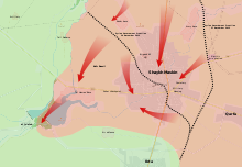
Early on 27 December, the 15th Brigade of the 5th Armoured Division of the Syrian Army launched the operation to capture Al-Shaykh Maskin, attacking its northern and eastern flanks.
[20] The following day, government forces continued with their attempts to take full control of Al-Shaykh Maskin[21] and captured the eastern part of the town.
[23] They reached the town's main square,[24] as well as the Al-'Umari Mosque (north of the city center), while the rebels issued a distress call for reinforcements.
At the same time, the 15th Brigade, supported by NDF units, continued making attempts to advance to Tal Hamad hill, west of the town, but were unsuccessful.
[35] Opposition sources confirmed that since the start of the battle for Al-Shaykh Maskin the rebels had suffered ”major material and human losses", but reported they were still preparing to make new attempts to regain the base.
[39] Between 23 and 24 January, the military captured Al-Zaheriyah school and its surrounding area, as well as the town of Al-Burj on the outskirts of Al-Shaykh Maskin, after more than 40 air-strikes were conducted.
[41] Still, Army advances continued as they took control of more positions in the town,[42] which included the Al-Bassam Mosque, parts of the Al-Diri neighborhood and large sections of the Saydaliyat road.
[44] The next morning, the Syrian Army launched its operation from the north side of the town and rapidly advanced, linking up with troops coming in from the east.