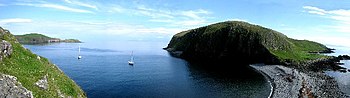
Shiant Islands
The Shiant Islands[1] (/ʃænt/; Scottish Gaelic: Na h-Eileanan Mòra [nə ˈhelanən ˈmoːɾə] or Na h-Eileanan Seunta [nə ˈhelanən ˈʃiant̪ə] ⓘ) or Shiant Isles are a privately owned island group in the Minch, east of Harris in the Outer Hebrides of Scotland.
[2] The name Shiant is from the Scottish Gaelic Na h-Eileanan Seunta, which means the "charmed", "holy" or "enchanted isles".
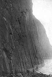
Dolerite columns on the north side of Garbh Eilean are over 120 metres (390 feet) tall and about 2 m (6 ft 7 in) in diameter.
They are much higher in places than those at Staffa and the Giant's Causeway, but similar in that they were formed by the slow cooling of volcanic rocks deep underground.
[10] In some places, the basalt is overlain by Jurassic mudstone, which weathers to form much more fertile soil than is present elsewhere in the Western Isles.
Nicolson (2002) calls this "vault" on Toll a' Roimh at the north east end of Garbh Eilean the "Hole of the Seals" and describes rowing a dinghy through it.
Island-More hath a chapel in it dedicated to the Virgin Mary, and is fruitful in corn and grass; the island joining to it on the west is only for pasturage.
[17] The Shiant Islands have a large population of seabirds, including tens of thousands of Atlantic puffins that breed in burrows on the slopes of Garbh Eilean, and significant numbers of common guillemots, razorbills, northern fulmars, black-legged kittiwakes, common shags, gulls and great skuas.
Analysis of their stomach contents had shown that they ate seabirds, but it could not be determined whether they preyed on live birds or simply scavenged dead ones.
[24][25][26] In March 2018, the Shiant Islands were deemed to have satisfactorily completed the internationally agreed two-year eradication period, and were officially declared rat-free.