Siachen conflict
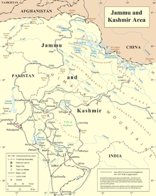
[21][page needed] Following the UN-mediated ceasefire in 1949, the line between India and Pakistan was demarcated up to point NJ9842 at the foot of the Siachen Glacier.
"[20] The detailed description of its northern end stated that from Chimbatia in the Turtok sector "the line of control runs north-eastwards to Thang (inclusive to India), thence eastwards joining the glaciers."
In 1956–58, a scientific team led by the Geological Survey of India recorded its findings publicly including information about the Siachen and other glaciers.
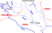
[26] In 1957 Pakistan permitted a British expedition under Eric Shipton to approach the Siachen glacier through the Bilafond La, and recce Saltoro Kangri.
[27][page needed] Five years later a Japanese-Pakistani expedition put two Japanese and a Pakistani Army climber on top of Saltoro Kangri.
[30][full citation needed] In 1978 a German Siachen-Kondus Expedition under the leadership of Jaroslav Poncar (further members Volker Stallbohm and Wolfgang Kohl, liaison officer major Asad Raza) entered Siachen via Bilafond La and established the base camp on the confluence of Siachen and Teram Shehr.
Unusually for the normally secretive Indian Army, the news and photographs of this expedition were published in The Illustrated Weekly of India, a widely circulated popular magazine.
[32] The first public acknowledgment of the maneuvers and the developing conflict situation in the Siachen was an abbreviated article titled "High Politics in the Karakoram" by Joydeep Sircar in The Telegraph newspaper of Calcutta in 1982.
At army headquarters in Rawalpindi, the discovery of repeated Indian military expeditions to the glacier drove Pakistani generals to the idea of securing Siachen before India did.
In the haste to pull together operational resources, Pakistan planners made a tactical error, according to a now-retired Pakistani army colonel.
For this purpose units from Pakistan Army SSG (1st and 3rd battalions) assembled a major task force at the newly constructed Khaplu garrison.
P. C. Katoch, Col. Konsam Himalaya Singh seized control of pt 5770 (Naveed Top/Cheema Top/Bilal Top) in the southern edge of the Saltoro defense line from Pakistan troops.
[49] In his memoirs, former Pakistani president General Pervez Musharraf states that Pakistan lost almost 986 square miles (2,550 km2) of territory that it claimed.
In an academic study with detailed maps and satellite images, co-authored by brigadiers from both the Pakistani and Indian military, pages 16 and 27: "Since 1984, the Indian army has been in physical possession of most of the heights on the Saltoro Range west of the Siachen Glacier, while the Pakistan army has held posts at lower elevations of western slopes of the spurs emanating from the Saltoro ridgeline.
[57][58] Despite the high cost India maintains presence, as Pakistani control of Siachen would allow them to put radar and monitor all Indian airforce activity in Ladakh.
Even if both sides agree to demilitarize a Pakistani occupation similar to 1999 will make it extremely difficult and expensive for India to reoccupy the glacier.
[61] When India occupied the Saltoro Ridge in April 1984, Benazir Bhutto publicly taunted the Pakistan Army as "fit only to fight its own citizens".
[61] An article in the Minneapolis Star Tribune stated: "Their combat over a barren, uninhabited world of questionable value is a forbidding symbol of their lingering, irreconcilability.
In the book Asymmetric Warfare in South Asia: The Causes and Consequences of the Kargil Conflict, Khan, Lavoy and Clary wrote: The Pakistan army sees India's 1984 occupation of the Siachen Glacier as a major scar, outweighed only by Dhaka's fall in 1971.
[65] General Ved Prakash Malik, in his book Kargil from Surprise to Victory, wrote: Siachen is considered a military setback by the Pakistan Army.
Pervez Musharraf had himself once commanded the Special Services Group (SSG) troops in this area and made several futile attempts to capture Indian posts.
India built the world's highest helipad on the glacier at Point Sonam, 21,000 feet (6,400 m) above the sea level, to supply its troops.
Indian Prime Minister Narendra Modi visited Siachen on 23 October 2014 to celebrate Diwali with the troops and boost their morale.
US General visited for the purpose of "developing concepts and medical aspects of fighting in severe cold conditions and high altitude".
[85] In the early morning of 7 April 2012, an avalanche hit a Pakistani military headquarters in the Gayari Sector, burying 129 soldiers of the 6th Northern Light Infantry battalion and 11 civilian contractors.
[89] On 12 December, an avalanche killed 6 Indian soldiers in the Sub Sector Hanif in Turtuk area, when troops of the 1st Assam regiment were moving between posts.
[92] On 4 January 2016, four Indian soldiers of the Ladakh Scouts, were killed in an avalanche on the Southern Glacier while on patrol duty in Nobra Valley.
[93] On the morning of 3 February 2016, ten Indian soldiers including one Junior commissioned officer of the 6th Madras battalion were buried under the snow when a massive avalanche struck their post in the Northern Glacier at a height of 19,600 feet, on the Actual Ground Position Line.
[94] Pakistani officials offered their help in search and rescue operations 30 hours after the incident, although it was declined by Indian military authorities.
[95] During the rescue operations, the Indian army found Lance Naik Hanumanthappa alive, though in a critical condition, after being buried under 25 feet snow for 6 days.