Sinus Meridiani
In 1979-2001, the vicinity of this feature (with size about 1,600 kilometers (990 mi) and coordinates of the center 7°07′S 4°00′E / 7.12°S 4°E / -7.12; 4) was named Terra Meridiani.
[1] The name Sinus Meridiani was given to a classic albedo feature on Mars by the French astronomer Camille Flammarion in the late 1870s.
Prior astronomers, notably the German team of Wilhelm Beer and Johann Heinrich von Mädler and then the Italian Giovanni Schiaparelli, had chosen a particular point on Mars as being the location of its prime meridian when they charted their observations.
Accepting suggestions that dark areas on the surface of Mars were seas or oceans, Flammarion named a dark area at that point "Sinus Meridiani," literally "Meridian Bay," when he worked on his compilation and analysis of all prior observations of Mars.
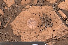
The concentration of spherules in bedrock could have produced the observed blueberry covering from the weathering of as little as one meter of rock.
On the other hand, a small amount of hematite that was present meant that there may have been liquid water for a short time in the early history of the planet.
Few rocks were visible on the surface where Opportunity landed, but bedrock that was exposed in craters was examined by the suite of instruments on the Rover.
Similar high levels were found by other rovers at Ares Vallis and Gusev crater, so it has been hypothesized that the mantle of Mars may be phosphorus-rich.
[14] When Opportunity traveled to the rim of the impact crater Endeavour, it found a white vein that was later identified as being pure gypsum.
[15][16] It was formed when water was discovered to harbor a then-unknown gypsum formation, at the time dubbed "Homestake," deposited the mineral into a crack in the rock.
Examination of bedrocks in Sinus Meridiani showed evidence of the mineral jarosite, which forms only in water.
Observations at the site have led scientists to believe that the area was flooded with water a number of times and was subjected to evaporation and desiccation.