Sirena Deep
[3] Scientists were alerted to the presence of the tear by the depth of strike-slip earthquakes, which were occurring too deep for them to be in the overriding plate.
The Sirena Deep lies at the intersection of the East Santa Rosa Bank Fault and a trench axis south of Guam.
The new name references the Guam folk-tale of Sirena, a young girl turned into half fish because of her disobedience.
On 7 May 2019 Victor Vescovo (Pilot) and Alan Jamieson (Chief Scientist) made the first crewed descent to the bottom of the Sirena Deep in the Deep-Submergence Vehicle Limiting Factor (a Triton 36000/2 model submersible) and measured a depth of 10,714 m (35,151 ft) ±10 m (33 ft) by direct CTD pressure measurements.
They spent 176 minutes on the bottom of the Sirena Deep and the deepest piece of mantle rock ever recovered from the surface of the western slope of the Mariana Trench was collected.

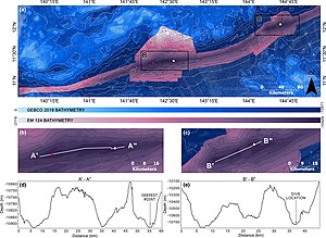
(a) Mariana Trench multibeam bathymetry data gridded at 75 m acquired on‐board the DSSV Pressure Drop overtop the GEBCO 2019 source grid (as shown in Figure 1) and the complete GEBCO 2019 grid with hillshade. EM 124 black contours at 500 m intervals, GEBCO 2019 grey contours at 1,000 m intervals. The white circle indicates the deepest point and submersible dive location, the white triangle indicates the submersible dive location from Sirena Deep, the red spot was the deepest point derived by van Haren et al., (2017).
(b) Challenger Deep.
(c) Sirena Deep.
Bathymetric cross sections A’–A” and B’–B” over Challenger Deep and Sirena Deep displayed in (d) and (e), respectively.
