California State Route 35
It runs along the ridge of the Santa Cruz Mountains from the high point of State Route 17 near Lexington Reservoir in Santa Clara County to State Route 1 just south of Daly City in San Mateo County, where it crosses SR 1 and loops around Lake Merced to become Sloat Boulevard in San Francisco.
It was originally designated State Route 5 (SR 5), but this had to be changed with the creation of Interstate 5 (I-5) in 1964 to avoid confusion between the two roads.
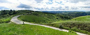
It bears the name Skyline Boulevard for a majority of its route along the ridge of the Santa Cruz Mountains to the west of Silicon Valley, passing by cities such as San Jose, Saratoga, and Palo Alto.
[10] Because of its scenic views and winding roadway, Skyline Boulevard and surrounding roads see substantial recreational motoring and bicycling use.
The route passes through or by several Midpeninsula Regional Open Space District preserves and other parks, from south to north: A number of streams originate near Skyline Boulevard, flowing to both Pacific Ocean and the Bay.
Route 35 continued west on Centralia Street and then north along Pioneer Boulevard until hitting San Antonio Drive at Rosecrans Avenue.
Route 35 would wind through Rose Hills and Avocado Heights as Workman Mill Road and would then turn into Puente Avenue at Valley Boulevard where it would continue to its end at U.S. 99 (which was concurrent with U.S.
On February 10, 2017, a huge washout washed away a 220-foot stretch of SR 35 about five miles south of the junction with State Route 9.
[11] Except where prefixed with a letter, postmiles were measured on the road as it was in 1964, based on the alignment that existed at the time, and do not necessarily reflect current mileage.