Sleaford
After a period of stagnation, in the late 20th and early 21st centuries the sale of farmland around Sleaford led to the development of large housing estates, causing the population to rapidly expand and the urban area to engulf Quarrington and Holdingham.
It houses supermarkets, shops and a large business park with offices and light manufacturing, and is home to the headquarters of North Kesteven District Council; three secondary schools (two of which are selective); four primary schools; three newspapers; police, fire and ambulance stations; several places of worship; many sports clubs; a leisure centre; and several medical and dental practices and care homes.
[2] Sleaford's urban area includes the town centre, focused on the marketplace (fronted by St Denys' Church), where Eastgate, Northgate, Southgate and Westgate meet.
Though some parts have been redeveloped in the 20th century, including the Riverside Shopping Precinct and Flaxwell House, the area follows a medieval street layout and is home to many of the town's oldest buildings; it is also the retail and commercial hub.
[9][10][11] South of the river, the town's urban area extends eastwards along Boston Road, which runs from Southgate to the A17 at Kirkby la Thorpe.
[9] Outside of the town's urban area, but included in the civil parish boundaries is Greylees, a settlement built in the early 21st century on the site of the former Rauceby Hospital.
[31] Lincolnshire's position on the east of the British Isles allows for a sunnier and warmer climate relative to the national average, and it is one of the driest counties in the UK.
Although only sparse pottery evidence has been found for the middle Iron Age period, 4,290 pellet mould fragments, probably used for minting and dated to 50 BC–AD 50, have been uncovered south-east of the modern town centre, south of a crossing of the River Slea and near Mareham Lane in Old Sleaford.
Where it passed through Old Sleaford, excavations have shown a large Roman domestic residence, associated farm buildings and field systems, and several burials.
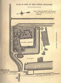
The now-ruined church at Old Sleaford has been discovered[45] and excavations of the market place have uncovered Anglo-Saxon remains from the 8th–9th centuries, indicating some form of enclosure with domestic features.
[52] There is little evidence of estate structure until the late Saxon period,[45] but there may have been a market and court before the Norman Conquest, and it may have been an economic and jurisdictional centre for surrounding settlements.
[51] Beresford's theory has been criticised by the historians Christine Mahany and David Roffe[n 3] who have reinterpreted the Domesday material and argued that in 1086 the Bishop's manor included the church and associated settlement which became "New" Sleaford.
[65][66] As the economic initiative passed more to burgesses and middlemen who formed ties with nearby towns such as Boston, evidence suggests that Sleaford developed a locally important role in the wool trade.
[77][78] The Carres and Herveys had a strong influence: while extracting dues from their tenants, they enforced their monopoly on charging tolls on market and cattle traders and for driving animals through the town.
[92] The town's rural location and transport links led in the late 19th century to the rise of two local seed merchants: Hubbard and Phillips, and Charles Sharpe; the former took over the Navigation Wharves, and the latter was trading in the US and Europe by the 1880s.
[93] The railway, Sleaford's rural location and its artesian wells, were key factors in the development of the 13-acre (5-hectare) Bass & Co maltings complex at Mareham Lane (1892–1905).
[99] Despite these advances, the slums around Westgate were crowded, lacking in sanitation and ridden by disease;[100] Northgate, as the entry point from the north along the turnpike, had also attracted notoriety for its taverns, lodging houses and brothels in the early 19th century: it was the "plague spot of the town".
[104] In the meantime, despite Anglicans dominating official institutions, non-conformist chapels were flourishing in the poorest parts of the town, at Westgate from the early 19th century and at Northgate after 1848, where they sought to provide spiritual care and education.
Lincolnshire's topography – flat and open countryside – and its location in the east of the country made it ideal for the airfields being constructed in the First World War.
[109][110] During the Second World War, Lincolnshire was "the most significant location for bomber command" and Rauceby Hospital, south-west of Sleaford, was requisitioned by the RAF as a specialist burns unit which the plastic surgeon Archibald McIndoe regularly visited.
The Council housing put up along Drove Lane proved insufficient for the low-income families after the Westgate slums were cleared in the 1930s; Jubilee Grove opened in that decade to meet the demand.
[106] In the post-war period, there were housing developments at St Giles Avenue, the Hoplands, Russell Crescent, Jubilee Grove and Grantham Road.
[122] According to a local authority report, Sleaford is also "the main retail, service and employment centre for people living in the town and in the surrounding villages".
Sleaford's population grew very slowly in the post-war years, reaching 7,975 by 1971,[155][156] largely due to the fact that Lord Bristol remained owner of the vast majority of the undeveloped land around the town.
[235][236] Until the 1880s, Sleaford's raw sewage was conveyed through "an antiquated system of drains, open cesspits and inadequate sewers";[237] the town's effluent was discharged into the Slea, which was also the source of drinking water.
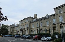
[268] Between 1902 and 1997, a mental institute, Rauceby Hospital, operated west of Quarrington, initially run by the county council and then the NHS from 1948; its patient enrolment peaked at 590 in 1958.
[284] Founded in 1867,[285] St Botolph's Church of England School is voluntary controlled, has 406 pupils aged 5 to 11 on roll,[286] and was rated "good" by Ofsted in 2023.
[297] Carre's is a boys' selective school (with a coeducational sixth form) founded in 1604 with 806 pupils on roll as of 2024;[298][299] it converted to an academy in 2011 and was judged to be "good" by Ofsted in 2023.
[416] During the Industrial Revolution, the Sleaford Navigation Company constructed offices along Carre Street (their reputed location is now grade-II-listed),[417][418] while the Gothic gasworks on Eastgate lit the town from 1839.
[438] The children's author Morris Gleitzman,[439] the actress and comedian Jennifer Saunders,[440] the singer Lois Wilkinson of the Caravelles,[441] Bernie Taupin (Elton John's lyricist),[442] and Eric Thompson, who narrated The Magic Roundabout television series, were all born in Sleaford.