Slope County, North Dakota
[2] The vote to create Slope County, by partitioning the lower portion of Billings, was held on November 3, 1914.
This was the final (as of 2019) alteration to that once-large Dakota county, as Bowman had been partitioned off in 1883, and Golden Valley was split off in 1910.
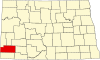
Slope County lies on the lower west side of North Dakota.
[6] The terrain slopes to the east and south; its highest area (except for isolated prominences, such as White Butte) is its northwestern corner, at 3,104 ft (946 m) ASL.
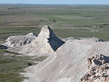
[8] White Butte, the highest natural point in North Dakota at an elevation of 3,506 ft (1,069 m), is in southeast Slope County.
Slope County voters have traditionally voted Republican.
In no national election since 1964 has the county selected the Democratic Party candidate (as of 2024).