Sognefjord
[4] Located in Vestland county in Western Norway, it stretches 205 kilometres (127 mi) inland from the ocean to the small village of Skjolden in the municipality of Luster.
[5] The name is related to Norwegian word súg- "to suck", presumably from the surge or suction of the tidal currents at the mouth of the fjord.
[6] The fjord runs through many municipalities: Solund, Gulen, Hyllestad, Høyanger, Vik, Sogndal, Lærdal, Aurland, Årdal, and Luster.
From Brekke the floor rises rapidly to Losna island, then drops gradually with a threshold at about 150 metres (500 ft) in the Solund area.
Thresholds occur in an area with sounds, valleys, and low land where the glacier was allowed spread out and lose its erosive effect.
[10] The inner end of the Sognefjord is southeast of a mountain range rising to about 2,000 metres (6,600 ft) above sea level and covered by the Jostedalsbreen, continental Europe's largest glacier.
The Sognefjord cuts through a northwestern gneiss area with a south-west to north-east structure, and penetrates the Caledonian fold through in the inner part.
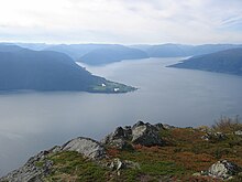
Larger villages on the fjord and its branches include Leirvik, Ytre Oppedal, Vadheim, Høyanger, Vikøyri, Balestrand, Hermansverk, Sogndalsfjøra, Gudvangen, Flåm, Aurlandsvangen, Lærdalsøyri, Årdalstangen, Gaupne and Solvorn.
Gudvangen is situated by the Nærøyfjord, a branch of the Sognefjord particularly noted for its unspoiled nature and dramatic scenery, and only 300 metres (1,000 ft) across at its narrowest point.
[18] Around the inner end of the fjord, three of Norway's famous stave churches have survived: Kaupanger and Urnes (along the shoreline) and Borgund (30 km or 20 mi into the Lærdal valley).