Solomon Sea plate
It roughly corresponds with the Solomon Sea east of Papua New Guinea.
The plate boundaries are associated with high earthquake activity as part of the New Britain subduction zone.
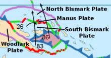
The tectonic regime in this part of the world is extremely complex and involves a number of minor as well as major plates.
[4] Its southeast margin runs along the Woodlark Rise, which extends into a transform fault called the Nubara Transform Fault marking the boundary with the adjoining Woodlark plate.
The complexities of its known geology, that of its island neighbour of New Ireland and the known Tabar, Lihir, Tanga and Feni Islands groups with undersaturated alkaline volcanics, some of which have been recently active, may not have resulted in a single accepted tectonic model to the north of the Solomon Sea plate that explains all observed features.