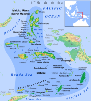
Weber Deep
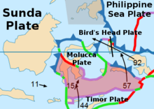
[1] Researchers believe that the Weber Deep was formed when part of the Earth's crust broke off along a 120 km (75 miles) extension of a fault on the ring of fire, called the Banda Detachment.
The break-off was caused by plate tectonics creating a back-arc basin rip in the ocean floor.
In parts of Weber Deep there is no oceanic crust on the sea floor due to the rip.
Researchers believe Weber Deep is the world's largest exposed fault on the ring of fire.
The closest land to Weber Deep is at the east end of the Banda Sea, surrounded by Watubela archipelago, Timor, Buru, Seram, Ambon and Kur Island.
[2] [3][4] Weber Deep is named after Max Carl Wilhelm Weber (1852–1937), who was the leader of a marine biological expedition, the Siboga expedition, using the 50.6-meter gunboat Siboga of the Dutch East Indies navy.