Somerset Coalfield
The Somerset coalfield stretched from Cromhall in the north to the Mendip Hills in the south, and from Bath in the east to Nailsea in the west, a total area of about 240 square miles (622 km2).
Those that survived until 1947 became part of the National Coal Board, but the expense of improving equipment and working conditions meant that these became uneconomical and the last pit closed in 1973.
[4] The Variscan orogeny involved lateral compression of the rock sequence resulting in the tight folding, fracturing and faulting of the sandstone and mudstone strata, and the associated Coal Measures.
[5] The complex geology and thin seams gained the field notoriety and three underground explosions, in 1893, 1895 and 1908 were amongst the first attributable solely to airborne coal dust.
[7][8] Smith worked for the Stracheys who owned Sutton Court, at one of their older mines, the Mearns Pit at High Littleton.
Smith noticed an easterly dip in the beds of rock—small near the surface (about three degrees) then greater after the Triassic rocks which led to him a testable hypothesis, which he termed the principle of faunal succession, and he began to determine if the relationships between the strata and their characteristics were consistent throughout the country.
During the early 17th century coal was largely obtained by excavating the outcrops and driving drifts which followed the seam into the ground.
Bulley notes "The problem ... was rendered far worse by the state of the roads in Somerset, which were notorious down to the middle of the 18th century.
Thus in 1617 the inhabitants of Stoke St Michael ... complained that "of late by reason of many coalmines ... the highways there are much in decay and grown very founderous".
Turnpikes facilitated the movement of coal, and John Billingsley[24] enthused "Nothing so much contributes to the improvement of a county as good roads.
Such a need implied a canal project, following Lord Middleton's dictum "Water transport is what all coal owners must aim at".
The total tonnage of coal produced by the coalfield increased throughout the 19th century, reaching a peak around 1901, when there were 79 separate collieries and production was 1.25 million tons per annum.
The conversion of Portishead power station from coal to oil and reduced national demand together with competition from more economical coalfields[32] led to the closure of the last two pits, Kilmersdon and Writhlington, in September 1973.
[1][30] Although there are still the remains of mines, disused or redeveloped buildings and a few spoil tips, most have been removed or landscaped[33][34] and the area has returned to a largely rural nature.
[35] The Colliers Way (NCR24) national cycle route passes landmarks associated with the coalfield,[36] and other roads and footpaths follow tramways developed during the coal mining years.
[37] The cycleway runs from Dundas Aqueduct to Frome via Radstock,[38] and is intended to provide part of a continuous cycle route to Southampton and Portsmouth.
[30] The Earl of Warwick's estates included sawmills, quarries, brickworks and collieries in addition to agricultural holdings.
[67] There is very little obvious landscape evidence remaining of the previous mining activities around Clutton, Temple Cloud, High Littleton and Timsbury.
The Batch was bare, like the Paulton ones until, according to locals, the wife of the owner of Camerton Court decided to pay for it to be planted with trees to improve the view.
[68] East of Camerton the coal is buried beneath newer rock strata, which meant that mining in the area was more difficult.
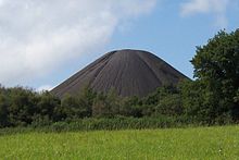
Relics of its industrial past are evident in the area, including the highly visible and distinct conical shaped Old Mills Batch with its generally unvegetated surface.
[77] The Duchy of Cornwall owned most of the mineral rights around Midsomer Norton and various small pits opened around 1750 to exploit these.
In 1763 coal was discovered in Radstock and mining began[82] on land owned by the Waldegrave family, Lords of the Manor since the English Civil War.
As part of the development of the Wiltshire, Somerset and Weymouth Railway, an 8-mile (13 km) line from Radstock to Frome was built to carry coal.
The Radstock railway site comprises approximately 8.8 hectares of land which has been subject to planning and development applications.
In 1911, partly as a result of the Norton Hill explosion, Winston Churchill was instrumental in the passing of the Coal Mines Act 1911 (1 & 2 Geo.
[98] After nationalisation after World War II the National Coal Board spent £500,000 on modernising the mine's infrastructure to give it the capability for annual production of 315,000 tons; however, manpower shortages and geological problems caused the pit to close in 1966.
[30] There were numerous coal workings in the area from Gurney Slade east to Mells around the villages of Holcombe, Coleford and Stratton-on-the-Fosse.
[105] The Vobster Breach colliery had a unique system of long coking ovens which, along with the other buildings, have been designated as a Scheduled monument.
[30][106] The boiler chimney of Oxley's Colliery near Buckland Dinham which operated for a few years in the 1880s is a Grade II listed building.