William Smith (geologist)
William 'Strata' Smith (23 March 1769 – 28 August 1839) was an English geologist, credited with creating the first detailed, nationwide geological map of any country.
[1] At the time his map was first published he was overlooked by the scientific community; his relatively humble education and family connections prevented him from mixing easily in learned society.
[4] Largely self-educated, Smith was intelligent and observant, read widely from an early age, and showed an aptitude for mathematics and drawing.
In 1791, Smith travelled to Somerset to make a valuation survey of the Sutton Court estate, and building on earlier work in the same area by John Strachey.
[5] He stayed in the area for the next eight years, working first for Webb and later for the Somersetshire Coal Canal Company, living at Rugborne Farm in High Littleton.
Smith's coal mine studies, combined with his subsequent observations of the strata exposed by canal excavations, proved crucial to the formation of his theories of stratigraphy.
This gave Smith a testable hypothesis, which he termed The Principle of Faunal Succession, and he began his search to determine if the relationships between the strata and their characteristics were consistent throughout the country.
[8] As a natural consequence, Smith amassed a large and valuable collection of fossils of the strata he had examined himself from exposures in canals, road and railway cuttings, quarries and escarpments across the country.
However, in the Somerset County Agricultural Society, he found a map showing the types of soils and vegetation around Bath and their geographical extent.
In the same year he claimed that a book he proposed to publish would provide geological information to enable the canal engineer to "choose his stratum, find the most appropriate materials, avoid slippery ground, or remedy the evil".
[12] Smith travelled extensively across Great Britain working as a mineral surveyor allowing him to meet prominent people such as Thomas Coke, 1st Earl of Leicester, and the Duke of Bedford.
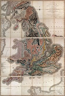
[17] Conventional symbols were used to mark canals, tunnels, tramways and roads, collieries, lead, copper and tin mines, together with salt and alum works.
[25] In the following issue Greenough replied, publicly declaring his view as being non-antagonistic by stating:Your correspondent considers me, in common with many other persons, actuated by feelings of hostility towards Mr. Smith.
I respect him for the important services he has rendered to geology, and I esteem him for the example of dignity, meekness, modesty, and candour, which he continually, though ineffectually, exhibits to his self-appointed champion.
[28] Smith's various projects, starting with a mortgage taken to purchase his estate at Tucking Mill in Somerset in 1798, accrued financial commitments that ran into a series of difficulties which he managed to withstand by borrowing money from sympathetic creditors and mortgagors and funding repayments by taking on a relentless schedule of work commissions between 1801 and 1819.
Between 1824 and 1834, Smith lived and was based in Hackness, then moving to Scarborough where he was responsible for the design of the Rotunda, a geological museum devoted to the Yorkshire coast, creating the cylindrical layout and arrangement of fossil display on sloping shelves.