South Cameroon Plateau
It slopes south and west until giving way to the Cameroon coastal plain in the southwest and the Congo River basin in the southeast.
The soils are ferrallitic and lateritic, with colouration ranging from red or brown in the interior to yellow on the coast.
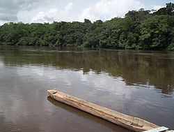
South of the Sanaga, those rivers flow steadily year-round, but the Sanaga and rivers north have a complex regime characterised by high- and low-water periods upstream and constant flow downstream.
From an altitude between 800 and 900 m.[4] there, the plateau slowly slopes south and west from the region of Bedzare and Meiganga.
To the southwest, large inselbergs and tall hills separated by deep gullies predominate.
[4] Some of the plateau's highest points are in this region, such as Mbam Minkom near Yaoundé (1,295 m), and Ntem massif near Ebolowa (1,400 m).
[1] To the southeast, the transition to the Congo Basin takes place on a gently sloping peneplain.
[4] Metamorphic rocks such as gneiss, mica, migmatites, and schists make up the South Cameroon Plateau's basement.
[7] The plateau's soils are predominantly ferrallitic and lateritic, the result of decomposing crystalline and sedimentary stone.
[10] Constant leaching of silica by percolating water prevents the soils from being very productive without fertilisation.
[8] The South Cameroon Plateau experiences an equatorial climate of the Guinea subtype.
[1] The Sanaga and rivers north of it follow a complex, or mixed, Sudano-Guinea regime because the territory they drain lies in both tropical and equatorial climate zones.
Below these stand thinner, shorter trees with large concentrations of leaves at their tops.
[20] Tree species include azobé, bubinga, ebony, iroko, mahogany, and obeche.