South Fork McKenzie River
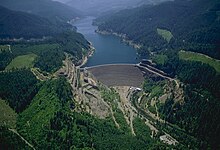
It is a multipurpose United States Army Corps of Engineers project built in 1963 to generate hydroelectricity and limit flooding.
The South Fork McKenzie River begins in the Mink Lake Basin of the Cascade Range at an elevation of about 4,600 feet (1,400 m) above sea level.
Lakes near the river's headwaters include Mink, Porky, Mud, Plumb, Goose, and Corner, as well as many smaller water bodies.
[3] Fishing, camping, hiking, swimming, and boating are among the forms of recreation pursued in the South Fork McKenzie River watershed.
The United States Forest Service maintains three campgrounds—Cougar Crossing, Slide Creek, and Sunnyside—near the reservoir, with opportunities for hiking and picnicking as well as camping.
[10] Terwilliger Hot Springs, near the confluence of Rider Creek and the South Fork, offers six clothing-optional soaking pools in sight of a waterfall and "a spectacular rock formation".
[11] The popular hot springs, with a parking lot off Forest Road 19, requires a day-use pass that can be paid for on-site.
[11] Whitewater enthusiasts sometimes run all or part of an 8.5-mile (13.7 km) stretch of the river from above French Pete Campground to Cougar Reservoir.