Willamette River
Originally created by plate tectonics about 35 million years ago and subsequently altered by volcanism and erosion, the river's drainage basin was significantly modified by the Missoula Floods at the end of the most recent ice age.
Rich with sediments deposited by flooding and fed by prolific rainfall on the western side of the Cascades, the Willamette Valley is one of the most fertile agricultural regions in North America, and it was thus the destination of many 19th-century pioneers traveling west along the Oregon Trail.
More than half a dozen bridges not open to motorized vehicles provide separate crossings for bicycles and pedestrians, mostly in the Eugene area, and several others are exclusively for rail traffic.
[5][6][7][8][9] Proposals have been made for deepening the Multnomah Channel to 43 feet (13 m) in conjunction with roughly 103.5 miles (166.6 km) of tandem-maintained navigation on the Columbia River.
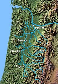
Significant tributaries from source to mouth include the Middle and Coast forks and the McKenzie, Long Tom, Marys, Calapooia, Santiam, Luckiamute, Yamhill, Molalla, Tualatin, and Clackamas rivers.
[18] The Willamette River basin was created primarily by plate tectonics and volcanism and was altered by erosion and sedimentation, including deposits from enormous glacial floods as recent as 13,000 years ago.
[23] During the Pleistocene, beginning roughly 2.5 million years ago, volcanic activity in the Cascades combined with a cool, moist climate to produce further heavy sedimentation across the basin, and braided rivers created alluvial fans spreading down from the east.
[26] The northern part of the watershed is underlain by a network of faults capable of producing earthquakes at any time, and many small quakes have been recorded in the basin since the mid-19th century.
[30] The basin's high population density, its nearness to this subduction zone, and its loose soils, which tend to amplify shaking, make the Willamette Valley especially vulnerable to damage from strong earthquakes.
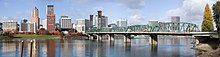
[34][35] Other cities in the watershed (but not on the main-stem river) with populations of 20,000 or more are Gresham, Hillsboro, Beaverton, Tigard, McMinnville, Tualatin, Woodburn, and Forest Grove.
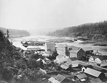
[49] In 1812, William Henry and Alfred Seton paddled up from Fort Astoria (PFC) on the Columbia River into the mouth of the Willamette, continued on until the falls portage (present-day Oregon City) and finished their journey at a flattening of both banks, the later site of Champoeg.
Free trappers Registre Bellaire, John Day and Alexander Carson hunted and traded furs during the winter of 1813-14 along the Willamette.
In 1829 Lucier established a land claim near the Champoeg trading post and started to settle, soon joined by Gervais (1831), Pierre Belleque (1833) and 77 French Canadian settlers by 1836.
[56] John McLoughlin, the Hudson's Bay Company (HBC) superintendent of the Columbia District, was one of the major contributors to the founding of the town in 1829.
[69] Between 1879 and 1885, the Willamette River was charted by Cleveland S. Rockwell, a topographical engineer and cartographer for the United States Coast and Geodetic Survey.
Although products such as lumber were often transported on an existing network of railroads in Oregon, these advances in navigation helped businesses deliver more goods to Portland, feeding the city's growing economy.
[75] In this, he was encouraged by Robert (Bob) Straub—the state treasurer and future Oregon governor (1975)—who first proposed a Willamette Greenway program during his 1966 gubernatorial campaign against McCall.
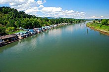
[47] Public uses of the river and land along its shores include camping, swimming, fishing, boating, hiking, bicycling, and wildlife viewing.
Elsewhere on the main stem, numerous minor flow-regulation structures force the river into a narrower and deeper channel to facilitate navigation and flood control.
[93] Due to these tall dams, Chinook salmon and steelhead are blocked from roughly half of their historic habitat and spawning grounds on the Willamette's major tributaries.
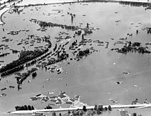
[118] Rainstorms and warm temperatures in December 1861 combined with a well-above-average snowpack in the Cascades created the largest Willamette River flood in recorded history.
Storms caused a major flood that swelled the Willamette and other rivers in the Pacific Northwest from December 1964 through January 1965, submerging nearly 153,000 acres (620 km2) of land.
[140] Since as early as 1869, with the introduction of a federally funded "snag puller" designed to keep the waterway clear, human habitation has affected the ecology of the river basin.
"[4] The construction of large federal dams on the Willamette's tributaries between 1941 and 1969 damaged the spawning grounds for spring Chinook salmon and steelhead.
The Izaak Walton League and the Oregon affiliate of the National Wildlife Federation countered the governor's veto with a ballot initiative, which passed in November 1938.
Scores were in the "fair" category farther downstream; the least favorable reading was 81 at the Swan Island Channel midpoint (RM 0.5, RK 0.8).
[153] The remaining forests close to the river include stands of black cottonwood, Oregon ash, willow, and bigleaf maple.
Among the 29 non-native species in the basin, there are brook, brown, and lake trout, largemouth and smallmouth bass, walleye, carp, bluegill, and others.
[154] In the central valley, several projects have been done to restore and protect wetlands[155] in order to provide habitat for bald eagles, Fender's blue butterfly, Oregon chub, Bradshaw's desert parsley, a variety of Willamette fleabane, and Kincaid's lupine.
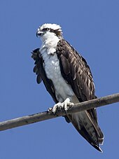
[156][157][158][159] In the early 21st century, osprey populations are increasing along the river, possibly because of a ban on the pesticide DDT and on the birds' ability to use power poles for nesting.