Southern Ocean
The Colony of Victoria's Legislative Council Act 1881 delimited part of the division of Bairnsdale as "along the New South Wales boundary to the Southern ocean".
While the IHO are often considered the authority for such conventions, the shift brought them into line with the practices of other publications (e.g. the CIA World Fact Book) which already adopted the principle that seas are contained within oceans.
[46][47] European geographers continued to connect the coast of Tierra del Fuego with the coast of New Guinea on their globes, and allowing their imaginations to run riot in the vast unknown spaces of the south Atlantic, south Indian and Pacific oceans they sketched the outlines of the Terra Australis Incognita ("Unknown Southern Land"), a vast continent stretching in parts into the tropics.
[45] The Spaniard Gabriel de Castilla, who claimed having sighted "snow-covered mountains" beyond the 64° S in 1603, is recognized as the first explorer that discovered the continent of Antarctica, although he was ignored in his time.
[45] The obsession of the undiscovered continent culminated in the brain of Alexander Dalrymple, the brilliant and erratic hydrographer who was nominated by the Royal Society to command the Transit of Venus expedition to Tahiti in 1769.
He turned south again and was stopped by ice in 61° 52′ S by 95° E and continued eastward nearly on the parallel of 60° S to 147° E. On 16 March, the approaching winter drove him northward for rest to New Zealand and the tropical islands of the Pacific.
In November 1773, Cook left New Zealand, having parted company with the Adventure, and reached 60° S by 177° W, whence he sailed eastward keeping as far south as the floating ice allowed.
The Antarctic Circle was crossed on 20 December and Cook remained south of it for three days, compelled after reaching 67° 31′ S to stand north again in 135° W.[45] A long detour to 47° 50′ S served to show that there was no land connection between New Zealand and Tierra del Fuego.
[45] Voyagers rounding Cape Horn frequently met with contrary winds and were driven southward into snowy skies and ice-encumbered seas; but so far as can be ascertained none of them before 1770 reached the Antarctic Circle, or knew it, if they did.
[57] The Imperial Trans-Antarctic Expedition of 1914, led by Ernest Shackleton, set out to cross the continent via the pole, but their ship, Endurance, was trapped and crushed by pack ice before they even landed.
Then Shackleton and five others crossed the Southern Ocean, in an open boat called James Caird, and then trekked over South Georgia to raise the alarm at the whaling station Grytviken.
[63][64] Explorer was the first cruise ship used specifically to sail the icy waters of the Antarctic Ocean and the first to sink there[65] when she struck an unidentified submerged object on 23 November 2007, reported to be ice, which caused a 10 by 4 inches (25 by 10 cm) gash in the hull.
[66] Explorer was abandoned in the early hours of 23 November 2007 after taking on water near the South Shetland Islands in the Southern Ocean, an area which is usually stormy but was calm at the time.
[69] British engineer Richard Jenkins designed an unmanned saildrone[70] that completed the first autonomous circumnavigation of the Southern Ocean on 3 August 2019 after 196 days at sea.
[71] The first completely human-powered expedition on the Southern Ocean was accomplished on 25 December 2019 by a team of rowers comprising captain Fiann Paul (Iceland), first mate Colin O'Brady (US), Andrew Towne (US), Cameron Bellamy (South Africa), Jamie Douglas-Hamilton (UK) and John Petersen (US).
Placer deposits, accumulation of valuable minerals such as gold, formed by gravity separation during sedimentary processes are also expected to exist in the Southern Ocean.
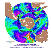
While the Southern is the second smallest ocean it contains the unique and highly energetic Antarctic Circumpolar Current which moves perpetually eastward – chasing and joining itself, and at 21,000 km (13,000 mi) in length – it comprises the world's longest ocean current, transporting 130 million cubic metres per second (4.6×10^9 cu ft/s) of water – 100 times the flow of all the world's rivers.
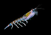
These nurture high levels of phytoplankton with associated copepods and Antarctic krill, and resultant foodchains supporting fish, whales, seals, penguins, albatrosses and a wealth of other species.
In many numerical models and observational syntheses, the Southern Ocean upwelling represents the primary means by which deep dense water is brought to the surface.
[99] Greater warming of this ocean water increases ice loss from Antarctica, and also generates more fresh meltwater, at a rate of 1100–1500 billion tons (GT) per year.
[108][109] Similar processes are taking place with Atlantic meridional overturning circulation (AMOC), which is also affected by the ocean warming and by meltwater flows from the declining Greenland ice sheet.
[111] It is possible that both circulations may not simply continue to weaken in response to increased warming and freshening, but eventually collapse to a much weaker state outright, in a way which would be difficult to reverse and constitute an example of tipping points in the climate system.
As the seafloor environment is very similar all around the Antarctic, hundreds of species can be found all the way around the mainland, which is a uniquely wide distribution for such a large community.
Various factors may aid in their distribution – fairly uniform temperatures of the deep ocean at the poles and the equator which differ by no more than 5 °C (9.0 °F), and the major current systems or marine conveyor belt which transport egg and larva stages.
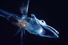
One Channichthyidae species, the mackerel icefish (Champsocephalus gunnari), was once the most common fish in coastal waters less than 400 metres (1,312 ft) deep, but was overfished in the 1970s and 1980s.
[132] The New Zealand sea lion (Phocarctos hookeri), one of the rarest and most localised pinnipeds, breeds almost exclusively on the subantarctic Auckland Islands, although historically it had a wider range.
[142] Increased solar ultraviolet radiation resulting from the Antarctic ozone hole has reduced marine primary productivity (phytoplankton) by as much as 15% and has started damaging the DNA of some fish.
[143] Illegal, unreported and unregulated fishing, especially the landing of an estimated five to six times more Patagonian toothfish than the regulated fishery, likely affects the sustainability of the stock.
International agreements came into force in late 1999 to reduce illegal, unreported, and unregulated fishing, which in the 1998–99 season landed five to six times more Patagonian toothfish than the regulated fishery.
Winter Quarters Bay forms a small harbor, on the southern tip of Ross Island where a floating ice pier makes port operations possible in summer.