Iceberg
[2][3] Smaller chunks of floating glacially derived ice are called "growlers" or "bergy bits".
[9] The largest known iceberg in the North Atlantic was 168 metres (551 ft) above sea level, reported by the USCG icebreaker Eastwind in 1958, making it the height of a 55-story building.
[17][failed verification] These bubbles are released during melting, producing a fizzing sound that some may call "Bergie Seltzer".
This sound results when the water-ice interface reaches compressed air bubbles trapped in the ice.
[20][21] Icebergs are generally white because they are covered in snow, but can be green, blue, yellow, black, striped, or even rainbow-colored.
[22] Seawater, algae and lack of air bubbles in the ice can create diverse colors.
In 1907, SS Kronprinz Wilhelm, a German liner, rammed an iceberg and suffered a crushed bow, but she was still able to complete her voyage.
In November 1913, the International Conference on the Safety of Life at Sea met in London to devise a more permanent system of observing icebergs.
The goal of the IIP was to collect data on meteorology and oceanography to measure currents, ice-flow, ocean temperature, and salinity levels.
They monitored iceberg dangers near the Grand Banks of Newfoundland and provided the "limits of all known ice" in that vicinity to the maritime community.
Aerial surveillance of the seas in the early 1930s allowed for the development of charter systems that could accurately detail the ocean currents and iceberg locations.
A computer was first installed on a ship for the purpose of oceanographic monitoring in 1964, which allowed for a faster evaluation of data.
Developed by the Canadian Space Agency, it provides images of Earth for scientific and commercial purposes.
This system was the first to use synthetic aperture radar (SAR), which sends microwave energy to the ocean surface and records the reflections to track icebergs.
The European Space Agency launched ENVISAT (an observation satellite that orbits the Earth's poles)[27] on March 1, 2002.
ENVISAT employs advanced synthetic aperture radar (ASAR) technology, which can detect changes in surface height accurately.
The Canadian Space Agency launched RADARSAT-2 in December 2007, which uses SAR and multi-polarization modes and follows the same orbit path as RADARSAT-1.
It assigns each iceberg larger than 10 nautical miles (19 km) along at least one axis a name composed of a letter indicating its point of origin and a running number.
The letters used are as follows:[29] The Danish Meteorological Institute monitors iceberg populations around Greenland using data collected by the synthetic aperture radar (SAR) on the Sentinel-1 satellites.
[31] The idea of towing large icebergs to other regions as a source of water has been raised since at least the 1950s, without having been put into practice.
[32] In 2019, a German company, Polewater, announced plans to tow Antarctic icebergs to places like South Africa.
[37][38] Fresh melt water released at depth is lighter, and therefore more buoyant, than the surrounding seawater causing it to rise towards the surface.
Iceberg B15 calved from the Ross Ice Shelf in 2000 and initially had an area of 11,000 square kilometres (4,200 sq mi).
[43] It has been hypothesized that this breakup may also have been abetted by ocean swell generated by an Alaskan storm 6 days earlier and 13,500 kilometres (8,400 mi) away.
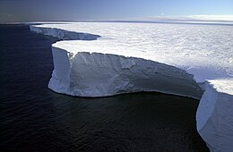
Icebergs in both the northern and southern hemispheres have often been compared in size to multiples of the 59.1 square kilometres (22.8 sq mi)-area of Manhattan Island.
[63] Caspar David Friedrich, The Sea of Ice, 1823–1824 is a polar landscape with an iceberg and ship wreck depicting the dangers of such conditions.
[64] William Bradford created detailed paintings of sailing ships set in arctic coasts and was fascinated by icebergs.
While on a return journey from Europe in 1841, her steamship encountered a field of icebergs overnight, during an Aurora Borealis.
The ship made it through unscathed to the next morning, when the sun rose and "touched the crowns, Of all those arctic kings.