Southern Ontario
It covers between 14 and 15% of the province, depending on the inclusion of the Parry Sound and Muskoka districts which also lie in the transitional area between northern and southern forest regions.
The transitional northern area of this primary region extends north to the Mattawa River and occupies part of the Grenville Geological Province of the Canadian Shield, which also extends northeast into southern Quebec; most of Northern Ontario lies within the Superior Geological Province.
The French explored and colonized Territorial Southern Ontario in the 17th century and forged relations with the Wyandot Huron people, based around the Georgian Bay/Lake Simcoe area.
Other Iroquoian speaking people to the south were the Petun and Neutral Nation, and further northeast, Algonquins inhabited the upper Ottawa River/Madawaska Valley areas and the Mississaugas moved south from northern Lake Huron, settling lands in both the Kawartha region and just west of Toronto.
Following the Seven Years' War, the British wrested control of Southern Ontario, and more significant colonization efforts were spurred on by the arrival of United Empire Loyalists brought on by the American Revolution.
Southern Ontario was where a large portion of the battles took place during the War of 1812,[3] and was a major destination for escaping slaves using the Underground Railroad.
[4] Following the enactment of Prohibition in the United States in 1919, Southern Ontario immediately became a hotbed of smuggling alcohol (spirit) across the border.
For thousands of years, Ontario has been home to indigenous aboriginal communities, with numerous nations with differing languages at the time of European contact.
[7] Factory closings because of industry restructuring and globalization (corresponding movement of jobs overseas and to non-unionized labour markets in the United States) have for the past few decades taken their toll.
This is most evident in the region's southern tier cities, which have large automobile or associated industrial bases, such as Windsor, London, St. Thomas and St. Catharines.
[8][9] Some parts of Southern Ontario are heavily entwined with bordering cities in New York and Michigan in terms of industry and people.
Other areas with heavy trade traffic with Southern Ontario include Montreal and the province of Quebec, parts of northern Ohio, and western Pennsylvania.
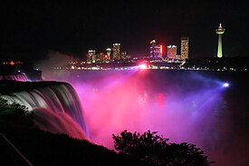
Some popular tourist attractions include the CN Tower, Parliament Hill, Niagara Falls, National Gallery of Canada, Canada's Wonderland, CNE, Caesars Windsor, Canadian War Museum, Toronto Zoo, Hockey Hall of Fame, Ripley's Aquarium of Canada, Royal Canadian Mint, Marineland, The Rideau Canal, the Canadian Museum of History and the Royal Ontario Museum.
[12] Ottawa is the most visited city in Canada by domestic tourists, hosting over 6.9 million Canadian visitors per year.
The line between the counties and regions of the south and the districts of the north can be considered a boundary between Southern and Northern Ontario.
This is disputed, however, as the demarcation line that is referenced in provincial documents is the Nipissing Passageway, originally an Indian trail between Georgian Bay and the Ottawa River.
1 Muskoka and Parry Sound are commonly regarded as transitional regions between Southern and Northern Ontario.
The 2011 census revealed that the major urban divisions of York, Halton, Peel, and Ottawa had the largest growth.
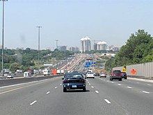
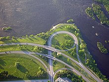
Southern Ontario has a highly developed transport system, including many highways, airports, ports, trains, and buses.
The region has a long history of marine transportation, with hundreds of millions of tonnes of cargo moving along the Great Lakes, and Saint Lawrence Seaway each year.
The Welland Canal is a vital part of the Great Lakes Waterway, allowing ships to avoid Niagara Falls.
In the summer months, Southern Ontario is susceptible to tornadoes[31] but far more often, straight line wind damage, hail and localized flooding from severe thunderstorms.
Southern Ontario also gets hurricane remnants, floods, ice storms, heavy fog, hail, and blizzards.