Southern Uplands
The Southern Uplands (Scottish Gaelic: Na Monaidhean a Deas) are the southernmost and least populous of mainland Scotland's three major geographic areas (the others being the Central Lowlands and the Highlands).
[1] These rocks were pushed up from the sea bed into an accretionary wedge during the Caledonian orogeny, roughly 400 million years ago (Ma), when the continents and terranes of Laurentia, Baltica and Avalonia collided.
Secondary mineralisation has further altered these Lower Palaeozoic rocks which are hosts for some distinctive springs, some of which have been exploited for tourism, such as those around Moffat.
The uplands support black and red grouse, mountain hares, golden eagles, hen harriers and some unusual plant species.
[17] The two unitary authorities of Dumfries and Galloway in the west and the Scottish Borders in the east cover almost all of the Southern Uplands.
Historically, i.e. prior to 1974, the region comprised the counties of Wigtown, Kirkcudbright, Dumfries, Roxburgh, Peebles, Selkirk and Berwick together with parts of Ayrshire, Lanarkshire, Midlothian and East Lothian.
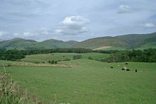
The geography of the region has caused it to be sparsely populated, a characteristic shared with the Highlands but in contrast to the Central Lowlands.
Tourism and recreation are of increasing importance: walking, fishing and grouse shooting are traditional pursuits and mountain biking has become popular in recent years.
Stocking frames were introduced in Hawick in 1771 and Galashiels' first woollen mill was built in 1800, but textile manufacture had a long history in the area: linen production had been a major industry since the Middle Ages.
[17] The Southern Uplands have always formed a major obstacle to travel between the more heavily populated and industrialised Central Belt of Scotland and England to the south.
[24] The 7stanes are seven mountain biking centres spanning the south of Scotland, from the heart of the Scottish Borders to Dumfries and Galloway.
The Seven Stanes: The Southern Uplands and especially those areas adjacent to the Anglo-Scottish border have a troubled and bloody history.
Scott also portrayed the social history, folklore and traditions of the Southern Uplands in several of his prose and verse works (such as The Lay of the Last Minstrel), as did James Hogg, known as the Ettrick Shepherd.