Southland Region
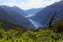
Fiordland's terrain is dominated by mountains, fiords and glacial lakes carved up by glaciations during the last ice age, between 75,000 and 15,000 years ago.
Farther north and east in Fiordland lie the Darran and Eyre Mountains which are part of the block of schist that extends into neighbouring Central Otago.
[10] Waitaha sailed on the Uruao waka, whose captain Rākaihautū named sites and carved out lakes throughout the area.
Descendants created networks of customary food gathering sites, travelling seasonally as needed, to support permanent and semi-permanent settlements in coastal and inland regions.
[6] In later years, the coastline was a scene of early extended contact between Māori and Europeans, in this case sealers, whalers and missionaries such as Wohlers at Ruapuke Island.
[12] On 10 June 1840, Tūhawaiki, a paramount chief of Kāi Tahu, signed the Treaty of Waitangi aboard HMS Herald at Ruapuke.
[14] In 1853, Walter Mantell purchased Murihiku from local Māori iwi, claiming the land for European settlement.
[15] Part of the agreement was that schools and hospitals would be provided alongside each Kāi Tahu village; this promise was not fulfilled.
The boundaries of the land sold were also not made sufficiently clear, with Kāi Tahu always maintaining that Fiordland was not intended to be included in this purchase.
Under the influence of Menzies, Southland Province (a small part of the present Region, centred on Invercargill) seceded from Otago in 1861 following the escalation of political tensions.
[19] In the 1880s, the development of an export industry based on butter and cheese encouraged the growth of dairy farming in Southland.
[20] Now, Edendale is the site of the world's largest raw milk-processing plant,[21] and Southland's economy is based on agriculture, tourism, fishing, forestry, coal, and hydropower.
The large rural electorate of Southland, held by Joseph Mooney of the New Zealand National Party, also includes some of the neighbouring Otago Region.
Politically, Southland proper extends from Fiordland in the west past the Mataura River to the Catlins the east.
[24] Fiordland's terrain is dominated by mountains, fiords and glacial lakes carved up by glaciations during the last ice age, between 75,000 and 15,000 years ago.
Farther north and east in Fiordland lie the Darran and Eyre Mountains which are part of the block of schist that extends into neighbouring Central Otago.
[9] Farther east of the Waiau River, the Southland Plains predominate which include some of New Zealand's most fertile farmlands.
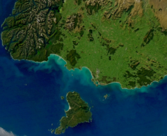
Off the coast of Southland lies the Great South Basin which stretches over 500,000 square kilometres (190,000 sq mi)—an area 1.5 times New Zealand's land mass.
Due to its closer proximity to the South Pole, the Aurora Australis or "Southern Lights" are more commonly seen than in other regions.
The farthest coastal reaches of Fiordland are characterized by a limited temperature range with increasing rainfall at higher altitudes.
[36] Food-wise, cheese rolls are a Southland specialty [37] and swedes are a popular vegetable, prepared and eaten as are pumpkin and kumara (sweet potato) elsewhere in New Zealand.
The strength of Southland identity may owe something to the relatively high proportion of New Zealand-born in the region – 85% compared with 70% for New Zealand as a whole at the 2013 census.
[39] With a population of 51,700 Invercargill, the region's main centre and seat of local government, makes up half of Southland's total.
[40] The region's economy is based on agriculture, tourism, fishing, forestry and energy resources like coal and hydropower.
[10] The agriculture industry includes both sheep and dairy farming which both account for a significant proportion of the region's revenue and export receipts.
The cows produced 247,230 tonnes of milk solids, worth $1,780 million at the national average farmgate price ($7.20 per kg).
[10] Eastern Southland has significant deposits of lignite which are considered to be New Zealand's biggest fossil fuel energy resource.
[44] In July 2007 the New Zealand Government awarded oil and gas exploration permits for four areas of the Great South Basin.