Wellington Region
The region covers an area of 8,049 square kilometres (3,108 sq mi), and has a population of 550,600 (June 2024).
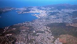
The Wellington urban area, including the cities of Wellington, Porirua, Lower Hutt, and Upper Hutt, accounts for 79 percent of the region's population; other major urban areas include the Kapiti conurbation (Waikanae, Paraparaumu, Raumati Beach, Raumati South, and Paekākāriki) and the town of Masterton.
[6] The council region covers the conurbation around the capital city, Wellington, and the cities of Lower Hutt, Porirua, and Upper Hutt, each of which has a rural hinterland; it extends up the west coast of the North Island, taking in the coastal settlements of the Kāpiti Coast District; east of the Remutaka Range it includes three largely rural districts containing most of Wairarapa, covering the towns of Masterton, Carterton, Greytown, Featherston and Martinborough.
In its more restrictive sense the region refers to the cluster of built-up areas west of the Tararua ranges.
The much more sparsely populated area to the east has its own name, Wairarapa, and a centre in Masterton.
Legend recounts that Kupe discovered and explored the region in about the tenth century.
The region occupies the southern tip of the North Island, bounded to the west, south and east by the sea.
To the west lies the Tasman Sea and to the east the Pacific Ocean, the two seas joined by the narrow and turbulent Cook Strait, which is 28 kilometres (17 mi) wide at its narrowest point, between Cape Terawhiti and Perano Head in the Marlborough Sounds.
The region covers 7,860 square kilometres (3,030 sq mi), and extends north to Ōtaki and almost to Eketāhuna in the east.
Physically and topologically the region has four areas running roughly parallel along a northeast–southwest axis: Wellington region covers 8,049.47 km2 (3,107.92 sq mi)[1] and had an estimated population of 550,600 as of June 2024,[2] with a population density of 68 people per km2.
Other main centres of population are on the Kāpiti Coast and in the fertile farming areas close to the upper Ruamahanga River in the Wairarapa.
Significantly, the Wellington region is home to over half of New Zealand's Tokelauan-born population.
The subnational GDP per capita was estimated at $74,251 in the same period, the highest of all New Zealand regions.
The company also leases wharf facilities to the Interislander and Bluebridge ferry services which operate across Cook Strait between Wellington and Picton in the South Island, and it provides support for cruise ships that visit Wellington each year.
It is a significant area of salt marsh and mudflat and a valuable feeding ground for many birds including the migratory Eastern bar-tailed Godwit, which flies all the way from Siberia to New Zealand to escape the harsh northern winter.