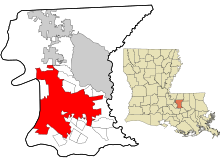
St. George, Louisiana
[2][4] A legal action[5] to challenge the incorporation[6] of St. George was filed in 19th Judicial District Court in East Baton Rouge Parish on November 4, 2019.
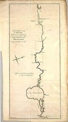
[9][10] After the French and Indian War ended in 1763, Bayou Manchac (originally known as Rivière d'Iberville or the Iberville River) became an international border between the British (West Florida) and Spanish (Isle of Orleans) colonial territories.
[11] In 1764, after encroachment from European settlers, the Alabama-Coushatta and Pakana Muscogee Indians migrated into Louisiana, to just north of Bayou Manchac.
[12] In 1765, the British built Fort Bute on the eastern bank of the Mississippi River at Bayou Manchac, not far from the present-day University Club Golf Course.
[citation needed] After a brief skirmish, they captured and demolished the fort in what would become the first Spanish action against the British during the American Revolutionary War.
[citation needed] During the War of 1812, U.S. Gen. Andrew Jackson had the mouth of Bayou Manchac filled with earth to prevent the British from using it to launch a surprise attack on New Orleans.
In 1828, American settlers reinforced that blockage with a large earthen dam to stifle flood waters from regularly inundating their properties.
Although it was later suggested that reconnecting the two bodies of water might actually help alleviate flooding in the area, the U.S. Army Corps of Engineers declined to.
[25] In June 2015, organizers attempted to form a new city but failed to collect enough signatures[26] (71 short of the minimum 17,859 required) on the petition (at least 25 percent of electors residing in an area proposed for incorporation is needed).
On June 12, 2020 Governor John Bel Edwards signed SB243, authored by Senator Bodi White and Representative Rick Edmonds, into law as Act 361 of the 2020 Regular Session of the Louisiana Legislature.
Relief sought by the plaintiffs included a favorable judgement denying the incorporation of St. George, or, alternatively, a parish-wide election to determine if the Plan of Government should be amended to allow for the formation of a new city.
[54] On February 7, 2020, St. George organizers filed a lawsuit seeking to invalidate the annexations in the United Plaza area.
[58] Annexation petitions requested following the certification date of the October 12, 2019 election to incorporate the City of St. George could possibly be declared null and void since the City of Baton Rouge at that date lacked the authority to annex any properties within the boundaries of St. George established in the State of Louisiana approved petition to incorporate as authorized by Title 33 of Louisiana law.
[64] In response, East Baton Rouge Parish developed a Stormwater Master Plan Implementation Framework to mitigate flooding concerns.
[69] In 2017, several residents from the Tiger Bend area raised concerns[70] about plans for an upscale subdivision located near the fault line.
[71] A Pleistocene prairie terrace, formed of alluvial deposits and wind-blown soil (Peoria loess), underlies most of East Baton Rouge Parish.
[72][67] In the St. George area, long slopes along portions of Highland Road can be seen where the prairie terrace meets the Mississippi River floodplain.
Browning, Rials, Murrell, and Talbot were heavily involved in the petition efforts to incorporate, while Potter was recommended to serve by East Baton Rouge Mayor-President Sharon Weston Broome.
Through BREC's Capital Area Pathways Project (CAPP), a network of connected trails and greenways is being developed throughout the parish.
[78] BREC's Blueways initiative provides paddling access to Bayou Fountain from Highland Road Community Park.
It includes a pond with an elevated wooden boardwalk and trails through more than 150 species of Southern native trees, shrubs and wildflowers.
[80] A historic marker near the pond helps to identify the route of pioneering Philadelphia naturalist William Bartram (1739–1823) through eight southern states, including Louisiana.
Facilities in the St. George area[61] that provide opportunities for informal education include: There are no east–west roads that run through the entire duration of the city limits.