Saint Louis River (Lake Superior tributary)
[4] Jay Cooke State Park is located near the mouth of the river and is the site of a canoe portage used by Native Americans, European explorers, fur traders, Voyageurs, coureurs des bois, and missionaries of the 18th and 19th centuries.
It was a rough trail of steep hills and swamps that began at the foot of the rapids above the neighborhood of Fond du Lac ("bottom of the lake") and climbed some 450 feet (140 m) to the present-day city of Carlton.
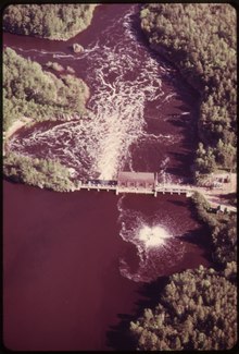
In 1987, the river became a designated Area of Concern, administered by the Environmental Protection Agency as a result of significant sediment contamination and habitat loss (see next section).
The Western Lake Superior Sanitary District (WLSSD) was established in 1971 to address serious pollution problems in the lower Saint Louis River Basin.
The cooperating agencies, including Wisconsin DNR and the Fond du Lac Band of Lake Superior Chippewa, did not agree to end the study.
In 2024, the Minnesota Pollution Control Agency began the process to develop a St. Louis River Watershed Mercury Total Maximum Daily Load, with a goal of obtaining EPA approval in 2027.
[8] Historical industrial use of the river, before the onset of modern environmental laws, has resulted in the degradation of habitat and sediments contaminated with: mercury, dioxins, polychlorinated biphenyls (PCBs), polycyclic aromatic hydrocarbons (PAHs), and other toxins.
[8] An impairment of beneficial uses means a change in the chemical, physical or biological integrity of the Great Lakes system sufficient to cause significant environmental degradation.
In 1983 the DNR, the Fond du Lac Band of Lake Superior Chippewa, and others began rebuilding spawning habitat and introducing baby sturgeon into the river.