2018–19 European windstorm season
There are two main naming lists, created by the national meteorological agencies of the UK and Ireland, and France, Spain and Portugal respectively.
The system subsequently completed an extratropical transition on 16 September as it accelerated north-eastwards towards the British Isles,[11] with the outer bands of Storm Helene causing minimal impacts in north-western Spain and Portugal.
Subsequently, Helene emerged into the Norwegian Sea and stalled off the coast of Norway as a weakened system,[14] finally being absorbed by Storm Bronagh approaching from the south-west on 21 September.
The highest wind gust recorded in the Republic of Ireland was 143 km/h (89 mph; 77 kn) at Mace Head weather station in County Galway.
A caravan was blown over a cliff onto a beach near the village of Claddaghduff in County Galway, killing a woman who was visiting from Switzerland.
[17] There was also severe tree damage in the Galway City and County region, which led to numerous school and road closures.
[24] In Greenock in Scotland, the MS Nautica cruise ship broke free from her moorings and drifted for several hours before being rescued by tugboats.
[17] In Cumbria, fallen trees and power lines caused disruption to transport and left homes without power; overturned lorries caused the M6 motorway to close for several hours, and Virgin Trains services along the West Coast Main Line were delayed or cancelled between Preston and Glasgow Central.
[26] After clearing the UK, Ali made landfall in Norway, where several thousand homes were left without power in the west of the country.
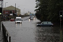
[36] East Midlands Trains reported that severe flooding from the River Sheaf and Porter Brook was affecting Sheffield station, with services delayed or cancelled as a result.
[35] Bus services across the city were also suspended as the flooding peaked during the evening rush hour, stranding thousands of people.
Flooding was additionally reported in Sheffield City Centre, Bradway, Intake, Meersbrook, Nether Edge and Woodseats amongst other districts.
[45] At 21:00 UTC, Callum subsequently moved across Iceland and the Norwegian Sea as a weakened system, continuing northwards into the Arctic and out of the basin by 16 October.
[55] Leslie transitioned into a powerful extratropical cyclone on 13 October and made landfall in Figueira da Foz in central Portugal with sustained winds of 110 km/h (70 mph; 61 kn) at 21:10 UTC that day.
Red weather warnings were issued for 13 out of 18 districts in Portugal by the time Leslie made landfall, including Lisbon.
[60] Leslie weakened as it moved across the Iberian peninsula, with winds gusting up to a maximum of 97 km/h (60 mph; 52 kn) reported across Spain.
[61] Severe thunderstorms and flash flooding were reported, with Carcassonne recording 180 mm (7.1 in) of rainfall in a five-hour period on 14 October.
[67] Adrian subsequently continued northwards and made landfall along the French Riviera later that day, bringing high winds, heavy rain, thunderstorms and a severe storm surge along the south coast of France.
[73] A trailing weather front from Adrian advanced into northern Italy causing severe coastal flooding, the Italian Riviera was severely damaged, the port of Rapallo completely destroyed with two hundred damaged and sunken boats, partially isolated Portofino by land with destruction of the coastal road, while on Adriatic coast, has killed six people in Venice and has damaged the Basilica of San Marco and left 75% of the city underwater;[69] across northern Italy, flooding and landslides from heavy rainfall killed a further four people.
[69] Heavy snowfall was reported in central France as the centre of Storm Adrian advanced northwards, and 200,000 houses lost power.
[70] On 30 October, Adrian continued northwards into Belgium and the Netherlands before emerging into the North Sea, having weakened considerably over land.
[66] Storm Beatriz formed on 6 November over the central Atlantic Ocean, being named by the Agencia Estatal de Meteorología of Spain.
Remaining largely stationary over the middle of the Atlantic, Beatriz steadily strengthened, reaching a central pressure of 960 hPa (28 inHg) on 7 November.
Storm Diana was named by the Portuguese Institute of Sea and Atmosphere (IPMA) on 24 November, with an orange warning being issued for the Azores.
[139] The fully extratropical remnants of Tropical Storm Ernesto crossed Ireland and the United Kingdom on 18–19 August, bringing heavy rainfall and winds of up to 64 km/h (40 mph; 35 kn),[144][145] unseasonably strong for the time of year.
[150] Air and rail travel was disrupted across Germany, Austria and Switzerland due to high winds and fallen trees on train tracks.
[155] Kuisma brought winds gusting up to 114 km/h (71 mph; 61.6 kn; 31.7 m/s),[154] bringing down trees and power lines; however, damage was lower than initially expected.
[155] Storm Alfrida (named by the Swedish Meteorological and Hydrological Institute; FUB: Zeetje) crossed northern Europe on 1–2 January.
[157] In Sweden, where winds gusting up to 110 km/h (67 mph; 58 kn; 30 m/s) were recorded,[158] a commuter train collided with fallen trees along the Saltsjöbanan railway near Stockholm, although there were no injuries.
[159] The entire phone network on the island of Gotland was taken offline due to damage from Alfrida,[158] and more than 100,000 homes were left without power in mainland Sweden.