Freezing rain
Although these storms are not particularly violent, freezing rain is notorious for causing travel problems on roadways, breaking tree limbs, and downing power lines from the weight of accumulating ice.
This setup is known as cold-air damming, and is characterized by very cold and dry air at the surface within the region of high pressure.
As the rain continues to fall, it passes through a layer of subfreezing air just above the surface and cools to a temperature below freezing (0 °C or 32 °F or 273 K).
If this layer of subfreezing air is sufficiently deep, the raindrops may have time to freeze into ice pellets (sleet) before reaching the ground.
In the layer where the snow is melting, however, the wet flakes still have a large diameter and are coated with water, so the radar returns are much stronger.
Then, it is possible to associate this clue with surface observations and numerical prediction models to produce output such as the ones seen on television weather programs, where radar echoes are shown distinctly as rain, mixed, and snow precipitations.
When the freezing rain or drizzle is light and not prolonged, the ice formed is thin and usually causes only minor damage (relieving trees of their dead branches, etc.).
In February 1994, a severe ice storm caused over $1 billion in damage in the Southern United States, primarily in Mississippi, Tennessee, Alabama, and Western North Carolina, especially the Appalachians.
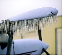
All three factors increase stalling speed and reduce aircraft performance, making it very difficult to climb or even maintain altitude.
However, freezing rain is accompanied by a temperature inversion aloft, meaning that aircraft are required to climb to move into warmer air, which is a potentially difficult and dangerous task with even a small amount of ice accumulation.
The ATR-72, a twin-engine turboprop carrying 68 people, entered a holding pattern 105 km or 65 mi southeast of O'Hare.
On one occasion, freezing rain was observed to settle on hanging rotting apples and icing over them immediately, creating a glaze coating.
A similar phenomenon was observed in February 2015 in Greenville, North Carolina, when a Jeep that had backed out of the parking lot left behind an ice shell of its lower front part (with grille and bumper) standing on icicles.