Stream order
[5][6] The Strahler order is designed to reflect the morphology of a catchment and forms the basis of important hydrographical indicators of its structure, such as its bifurcation ratio, drainage density and frequency.
A general lower boundary for the definition of a "stream" may be set by defining its width at the mouth or, referencing a map, by limiting its extent.
It can be made relatively scale-independent by using suitable normalization and is then largely independent of an exact knowledge of the upper and lower courses of an area.
The vector order then increases as it traces upstream and converges with other smaller streams, resulting in a correlation of higher-order numbers to more highly elevated headwaters.
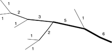
Both Horton's and Strahler's methods established the assignment of the lowest order, number 1, starting at the river's headwater, which is the highest elevation point.
Horton's and Strahler's rules form the basis of programming algorithms that interpret map data as queried by Geographic Information Systems.
Research activity following Strahler's 1952 report has focused on solving some challenges when converting two-dimensional maps into three-dimensional vector models.
Depending on the scale of the GIS map, some fine detail of the tree structure of a river system can be lost.
Research efforts by private industry, universities and federal government agencies such as the EPA and USGS have combined resources and aligned focus to study these and other challenges.
The principal intent is to standardize software and programming rules so GIS data is consistently reliable at any map scale.