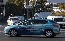
Google Street View
[8] With the release of Android 4.2 in November 2012, Google invited users to contribute panoramas of their own using supported devices.
[13] In October, support for Google Cardboard was announced, allowing users to utilize Street View in 360-degree virtual reality.
In August 2017, Google also allowed users to create their own Street View-like blue paths for the connected photospheres that are sufficiently close to one another.
On September 5, 2017, Google announced that they were improving the quality of the street view panoramic photo by revamping its mapping vehicles with all-new high-resolution camera systems and artificial intelligence.
[21][22] Google shut down its dedicated Street View app on Android and iPhone and ended support on March 21, 2023.
[28][29][needs update] The drag-and-drop Pegman icon is the primary user interface element used by Google to connect Maps to Street View.
[30] At Loch Ness, Pegman turns into Nessie wearing a tartan hat, where Street View includes coverage of the lake itself as well as the nearby A82 road and rural areas.
The company has partnered with local technology businesses Tech Mahindra and Genesys to aid in the relaunch of the service.
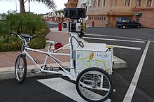
A trike (tricycle) was developed to record pedestrian routes, including Stonehenge and other UNESCO World Heritage Sites.
[45] Laser range scanners from Sick AG for measuring up to 50 meters at 180° in the front of the vehicle[46] are used for recording the actual dimensions of the space being photographed.
[39] In September 2018, Google announced it would integrate air quality sensors from Aclima into its global fleet of Street View vehicles.
[48] Privacy advocates have objected to Google Street View, pointing to views found to show men leaving strip clubs, protesters at an abortion clinic, sunbathers in bikinis, and people engaging in activities visible from public property that they do not wish to be seen publicly.
[54] In May 2010, it was revealed that Google had collected and stored payload data from unencrypted Wi-Fi connections as part of Street View.
Imagery obtained from Google Street View has been used for research purposes, e.g., quantifying greenery, health studies, and assessing cycling conditions.
[70] Michael Wolf won an honourable mention in Daily Life in the 2011 World Press Photo competition for some of his work using Google Street View.
[71] Mishka Henner was shortlisted for the 2013 Deutsche Börse Photography Prize in November 2012 for his series 'No Man's Land', which depicts sex workers at rural roadside locations.
[72] Canadian artist Sylvia Grace Borda worked in conjunction with John M. Lynch between 2013 and 2014[73][74] to insert the first staged tableaux[75] into the Google Street View engine.
[76] Borda has independently continued to author the Google Street View engine, and in 2017, she created the tableaux series the Kissing Project.
[77] Swedish programmer Anton Wallén developed a game called GeoGuessr, which places players in a Google Street View and has them guess its location.