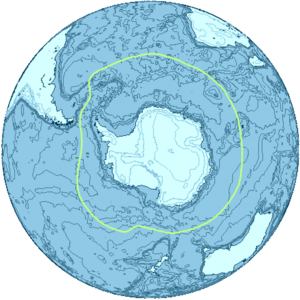
Subantarctic
The subantarctic region includes many islands in the southern parts of the Atlantic, Indian, and Pacific oceans, especially those situated north of the Antarctic Convergence.
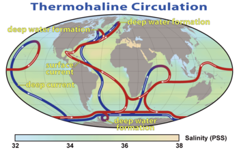
Extending from the sea surface to depths of 2000–4000 meters, and with a width of as great as 2000 kilometers, the ACC transports more water than any other ocean current.
[2] The ACC carries up to 150 Sverdrups (150 million cubic meters per second), equivalent to 150 times the volume of water flowing in all the world's rivers.
[4] Another factor that contributes to the climate of the subantarctic region, though to a much lesser extent than the thermohaline circulation, is the formation of Antarctic Bottom Water (ABW) by halothermal dynamics.
The resulting reductions in the subduction and transport capacity of SAMW and AAIW water masses could potentially decrease the absorption and storage of CO2 in the Southern Ocean.
Volcanic activity has been observed in this area since the mid-1980s, with fresh lava flows on the southwest flanks of Heard Island.
Satellite imagery shows that McDonald Island increased in size from about 1 to 2.5 square kilometers between 1994 and 2004, as a result of volcanic activity.
[10] In addition to new land being produced by volcanism, global warming of the climate is causing the retreat of glaciers on the islands (see section below ).
These combined processes produce new ice-free terrestrial and freshwater ecoregions, such as moraines and lagoons, which are now available for colonization by plants and animals.
Due to the very high numbers of seabirds and marine mammals on Heard Island, the area is considered a "biological hot spot".
[10] The marine environment surrounding the islands features diverse and distinctive benthic habitats that support a range of species including corals, sponges, barnacles and echinoderms.
This marine environment also serves as a nursery area for a range of fishes, including some species of commercial interest.
[22] The presence of glaciers on Heard Island provides an excellent opportunity to measure the rate of glacial retreat as an indicator of climate change.
Between 1949 and 1954, marked changes were observed to have occurred in the ice formations above 5,000 feet (1,500 m) on the southwestern slopes of Big Ben, possibly as a result of volcanic activity.
[23] Retreat of glacier fronts across Heard Island is evident when comparing aerial photographs taken in December 1947 with those taken on a return visit in early 1980.
A small team of scientists spent two months on the island, conducting studies on avian and terrestrial biology and glaciology.
Monitoring of climatic conditions continued, with an emphasis on the impact of Foehn winds on glacier mass balance.
The increase in the rate of ice loss suggests that the glaciers of Heard Island are reacting to ongoing climate change, rather than approaching dynamic equilibrium.