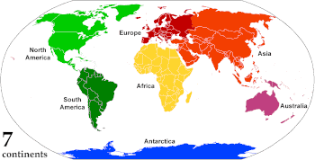
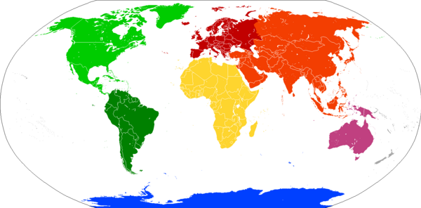
Continent
Oceanic islands are occasionally grouped with a nearby continent to divide all the world's land into geographical regions.
Under this scheme, most of the island countries and territories in the Pacific Ocean are grouped together with the continent of Australia to form the geographical region of Oceania.
[5] It was not applied only to very large areas of land—in the 17th century, references were made to the continents (or mainlands) of the Isle of Man, Ireland and Wales and in 1745 to Sumatra.
And in his 1752 atlas, Emanuel Bowen defined a continent as "a large space of dry land comprehending many countries all joined together, without any separation by water.
By convention, continents "are understood to be large, continuous, discrete masses of land, ideally separated by expanses of water".
Extrapolating the concept to its extreme, some geographers group the Australian continental landmass with other islands in the Pacific Ocean into Oceania, which is usually considered a region rather than a continent.
This viewpoint was common in the United States until World War II, and remains prevalent in some Asian six-continent models.
The following table provides areas given by the Encyclopædia Britannica for each continent in accordance with the seven-continent model, including Australasia along with Melanesia, Micronesia, and Polynesia as parts of Oceania.
Supercontinents, largely in evidence earlier in the geological record, are landmasses that comprise most of the world's cratons or continental cores.
Certain parts of continents are recognized as subcontinents, especially the large peninsulas separated from the main continental landmass by geographical features.
[62][63] In many of these cases, the "subcontinents" concerned are on different tectonic plates from the rest of the continent, providing a geological justification for the terminology.
[64] Greenland, generally considered the world's largest island on the northeastern periphery of the North American Plate, is sometimes referred to as a subcontinent.
Madagascar, the largest example, is usually considered an island of Africa, but its divergent evolution has caused it to be referred to as "the eighth continent" from a biological perspective.
[83][84] But the division was only carried through to the end of navigable waterways and "... beyond that point the Hellenic geographers never succeeded in laying their finger on any inland feature in the physical landscape that could offer any convincing line for partitioning an indivisible Eurasia ..."[82] Ancient Greek thinkers subsequently debated whether Africa (then called Libya) should be considered part of Asia or a third part of the world.
[85] From the Greek viewpoint, the Aegean Sea was the center of the world; Asia lay to the east, Europe to the north and west, and Africa to the south.
[94]Eratosthenes, in the 3rd century BCE, noted that some geographers divided the continents by rivers (the Nile and the Don), thus considering them "islands".
[96]Following the fall of the Western Roman Empire, the culture that developed in its place, linked to Latin and the Catholic church, began to associate itself with the concept of Europe.
By the middle of the 18th century, "the fashion of dividing Asia and Africa at the Nile, or at the Great Catabathmus [the boundary between Egypt and Libya] farther west, had even then scarcely passed away".
In 1501, Amerigo Vespucci and Gonçalo Coelho attempted to sail around what they considered the southern end of the Asian mainland into the Indian Ocean, passing through Fernando de Noronha.
[98] On return to Europe, an account of the voyage, called Mundus Novus ("New World"), was published under Vespucci's name in 1502 or 1503,[99] although it seems that it had additions or alterations by another writer.
[100] In 1507 Martin Waldseemüller published a world map, Universalis Cosmographia, which was the first to show North and South America as separate from Asia and surrounded by water.
trīṇi padā vi cakrame viṣṇurghopā adābhyaḥ | ato dharmāṇi dhārayan || The Gods be gracious unto us even from the place whence Vishnu strode Through the seven regions of the earth!
[112] In 1813, Samuel Butler wrote of Australia as "New Holland, an immense island, which some geographers dignify with the appellation of another continent" and the Oxford English Dictionary was just as equivocal some decades later.
However, this division of the Americas never appealed to Latin Americans, who saw their region spanning an América as a single landmass, and there the conception of six continents remains dominant, as it does in scattered other countries.
In geology, a continent is defined by continental crust, which is a platform of metamorphic and igneous rocks, largely of granitic composition.
The shield is a region where ancient crystalline basement rock (typically 1.5 to 3.8 billion years old) is widely exposed at the surface.
[120] The continents are accretionary crustal "rafts" that, unlike the denser basaltic crust of the ocean basins, are not subjected to destruction through the plate tectonic process of subduction.
Continents grow by accreting lighter volcanic island chains and microcontinents along these active margins, forming orogens.
The movement of plates has caused the continual formation and breakup of continents, and occasionally supercontinents, in a process called the Wilson Cycle.
[127] Some academics, such as the historical geographer Martin W. Lewis, argue that the systems we understand today are more rooted in social, political, and cultural history than in geological fact, a view particularly outlined in his book The Myth of Continents: A Critique of Metageography.