Pangaea
[3] Pangaea was C-shaped, with the bulk of its mass stretching between Earth's northern and southern polar regions and surrounded by the superocean Panthalassa and the Paleo-Tethys and subsequent Tethys Oceans.
[10] The concept that the continents once formed a contiguous land mass was hypothesised, with corroborating evidence, by Alfred Wegener, the originator of the scientific theory of continental drift, in three 1912 academic journal articles written in German titled Die Entstehung der Kontinente (The Origin of Continents).
[11] He expanded upon his hypothesis in his 1915 book of the same title, in which he postulated that, before breaking up and drifting to their present locations, all the continents had formed a single supercontinent that he called the Urkontinent.
[14] Wegener originally proposed that the breakup of Pangaea was caused by centripetal forces from Earth's rotation acting on the high continents.
[15] Arthur Holmes proposed the more plausible mechanism of mantle convection,[16] which, together with evidence provided by the mapping of the ocean floor following the Second World War, led to the development and acceptance of the theory of plate tectonics.
The seemingly close fit of the coastlines of North and South America with Europe and Africa was remarked on almost as soon as these coasts were charted.
Careful reconstructions showed that the mismatch at the 500 fathoms (3,000 feet; 910 meters) contour was less than 130 km (81 mi), and it was argued that this was much too similar to be attributed to coincidence.
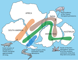
Fossil evidence for Pangaea includes the presence of similar and identical species on continents that are now great distances apart.
For example, fossils of the therapsid Lystrosaurus have been found in South Africa, India and Antarctica, alongside members of the Glossopteris flora, whose distribution would have ranged from the polar circle to the equator if the continents had been in their present position; similarly, the freshwater reptile Mesosaurus has been found in only localized regions of the coasts of Brazil and West Africa.
[25] The fourth-last supercontinent, called Columbia or Nuna, appears to have assembled in the period 2.0–1.8 billion years ago (Ga).
[30] Most of these landmasses coalesced again to form the relatively short-lived supercontinent Pannotia, which included large areas of land near the poles and a small strip connecting the polar masses near the equator.
Pannotia lasted until 540 Ma, near the beginning of the Cambrian and then broke up, giving rise to the continents of Laurentia, Baltica, and the southern supercontinent Gondwana.
In the early Ordovician, around 480 Ma, the microcontinent Avalonia—a landmass incorporating fragments of what would become eastern Newfoundland, the southern British Isles, and parts of Belgium, northern France, Nova Scotia, New England, South Iberia, and northwest Africa—broke free from Gondwana and began its journey to Laurentia.
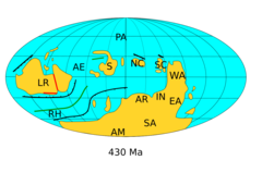
[32] Baltica, Laurentia, and Avalonia all came together by the end of the Ordovician to form a landmass called Euramerica or Laurussia, closing the Iapetus Ocean.
By the middle of the Silurian, 430 Ma, Baltica had already collided with Laurentia, forming Euramerica, an event called the Caledonian orogeny.
With Pangaea stretching from the South Pole across the equator and well into the Northern Hemisphere, an intense megamonsoon climate was established, except for a perpetually wet zone immediately around the central mountains.
Meanwhile, South America had collided with southern Laurentia, closing the Rheic Ocean and completing the Variscian orogeny with the formation the southernmost part of the Appalachians and Ouachita Mountains.
[40] By the time Pangaea broke up, in the Middle Jurassic, the seas swarmed with molluscs (particularly ammonites),[41] ichthyosaurs, sharks and rays, and the first ray-finned bony fishes, while life on land was dominated by forests of cycads and conifers in which dinosaurs flourished and in which the first true mammals had appeared.
The assembly of Pangaea disrupted the Intertropical Convergence Zone and created an extreme monsoon climate that reduced the deposition of coal to its lowest level in the last 300 million years.
During the Permian, coal deposition was largely restricted to the North and South China microcontinents, which were among the few areas of continental crust that had not joined with Pangaea.
[46] The lack of oceanic barriers is thought to have favored cosmopolitanism, in which successful species attain wide geographical distribution.
The first breakup of Pangaea is proposed for the late Ladinian (230 Ma) with initial spreading in the opening central Atlantic.
The second major phase in the break-up of Pangaea began in the Early Cretaceous (150–140 Ma), when Gondwana separated into multiple continents (Africa, South America, India, Antarctica, and Australia).
Also, at the same time, Madagascar and Insular India began to separate from Antarctica and moved northward, opening up the Indian Ocean.
India started to collide with Asia beginning about 35 Ma, forming the Himalayan orogeny and closing the Tethys Ocean; this collision continues today.
This motion, together with decreasing atmospheric carbon dioxide concentrations, caused a rapid cooling of Antarctica and allowed glaciers to form.
[57] The very active mid-ocean ridges associated with the breakup of Pangaea raised sea levels to the highest in the geological record, flooding much of the continents.