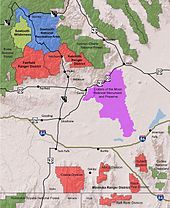
Sawtooth National Forest
The forest also contains the Albion, Black Pine, Boise, Boulder, Pioneer, Raft River, Smoky, Soldier, Sublett, and White Cloud mountain ranges, as well as Hyndman Peak, the ninth-highest point in Idaho at 12,009 feet (3,660 m) above sea level.
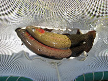
Plants and animals found only in the Sawtooth National Forest and adjacent lands include Christ's Indian paintbrush, Davis' springparsley, the South Hills crossbill, and the Wood River sculpin.
The first European descendants migrating from the eastern United States arrived in the area around the 1820s; they were mainly explorers, trappers, and prospectors, and they founded many of the current towns around what later became the forest.
The rest of Idaho's congressional delegation did not support the proposal, which occurred at a time when the National Park Service was taking a more preservation-oriented stance, and the bill died.
Subsequently, Sawtooth National Forest began to extensively develop recreation opportunities, including new campgrounds, trails, and roads.
[10] In 1960, Democratic Senator Frank Church of Idaho introduced legislation for a feasibility study to survey the area for national park status.
The SNRA bill was cosponsored by Republican Senator Len Jordan, a former governor and sheep rancher, because it preserved the area while also permitting traditional uses such as logging, hunting, and grazing.
ASARCO filed paperwork with the Forest Service to construct roads and to allow for an open pit mine below Castle Peak to extract the ore.
"[10] Samuelson lost his reelection bid that November in a rematch with Democrat Cecil Andrus, a supporter of preserving the forest who later (1977–81) served as U.S. interior secretary in the Carter Administration.
[10] In March 1971, Idaho's congressional delegation, which included senators Church and Jordan and Republican representatives Jim McClure and Orval Hansen, was finally united and introduced legislation to create the SNRA.
[30] Prior to the 2015 wilderness designations, the White Cloud and Boulder mountains were part of the largest unprotected roadless area in the United States outside of Alaska.
[32] In the absence of Congressional action that would designate the Boulder-White Clouds region as wilderness, the area had been studied for possible protection as a national monument by presidential proclamation under the Antiquities Act.
Former Secretary of the Interior Dirk Kempthorne initially studied the area for national monument status, but did not recommend it because Congressional action seemed likely.
Douglas-fir and quaking aspen are found in similar environments throughout the forest with understories of low shrubs, such as common snowberry and white spirea.
[20]: A-18 Ponderosa pine occupy the dry, lower elevations near the western edge of the forest and historically persisted due to the occurrence of frequent non-lethal fires.
In the slightly moister ponderosa pine forests grasses such as pinegrass are found with a cover of shrubs including white spirea, common snowberry, and mallow ninebark.
[20]: A-23 Idaho's rarest plant, the Christ's Indian paintbrush, is endemic to 200 acres (81 ha) on upper elevations of Mount Harrison in the Albion Mountains in the Minidoka District.
[20]: II-17 Invasive plants of particular concern in the forest include spotted knapweed, yellow starthistle, rush skeletonweed, leafy spurge, and cheatgrass.
[51][52][53][54] The northern and high elevation areas of the forest contain habitat for wolverines and the endangered Canadian lynx, but no recent sightings of these species have been reported.
Snakes species include bullsnakes and rubber boas, as well as western rattlesnakes, which are most likely to be found at lower elevations and in the Minidoka District.
[76][77] In 2005 the Valley Road Fire burned 40,800 acres (16,500 ha) in the White Cloud Mountains after being ignited from embers that came from a trash barrel which were blown out on a windy day.
The White Cloud Mountains are underlain by the gray granodiorite of the Idaho batholith, while some of the exposed rock is baked impure limestone from the Permian Grand Prize Formation.
In the Minidoka Ranger District, soils are generally productive, derived from volcanic and sedimentary material, shallow on steep slopes, and deep in the lowlands.
[96] There are over 1,100 lakes covering 7,600 acres (11.9 sq mi; 30.8 km2) and an estimated 7,500 miles (12,100 km) of temporary and permanent streams and rivers in the forest.
[10] Fur trappers of the Hudson's Bay Company discovered the Stanley Basin in the northern part of the forest in the 1820s, but mostly avoided it due to the scarcity of beaver.
[112]: 188–189 For early settlers, the welfare of their community was dependent upon timber supply, regulation of stream flow for irrigation, and use of the land for cattle range.
[113][114] The Black Pine Division of the forest was explored in the late 1800s, and the Tallman Mine began producing gold in the 1920s with production peaking from 1949 to 1954.
[2] Sheep drives were common in the Wood River Valley after the mining boom and shepherds from southern Idaho drove their flocks north to graze the upper elevation areas in Sawtooth National Forest.
Group size is restricted in the wilderness, open fires are not permitted in some high-use areas, and visitors are expected to follow Leave No Trace practices.
[2]All-terrain vehicles are allowed on over 500 mi (800 km) of forest roads and some trails, but access may be restricted depending on season and environmental conditions.