Swiss Plateau
In the north and northwest, the Swiss Plateau is sharply delimited geographically and geologically by the Jura Mountains.
Usually, the rising of the terrain to altitudes above 1500 metres AMSL (lime Alps, partly sub-alpine molasse), which is very abrupt in certain places, is taken as a criterion for delimitation.
Geologically, the Swiss Plateau is part of a larger basin that extends beyond the border of Switzerland.
The uppermost layer consists of gravel and glacial sediments that have been transported by the glaciers of the ice ages.
Geologically the most important layer of the Swiss Plateau is the thick molasse sequence that accumulated at the border of the Alps due to the rapid erosion of the concurrently uplifted mountains.
During the warm interglacials, the glaciers receded to the high alps (sometimes more than today) and subtropical vegetation spread in the plateau.
During the ice ages, the Rhône glacier split into two branches when leaving the Alps, covering the whole western Swiss Plateau and reaching today's regions of Solothurn and Aarau.
The glaciers formed the land by erosion, but also by base moraines (very fine stone meal) often several meters thick, and by the meltwater streams depositing gravel.
The greatest extension was reached by the glaciers of the Riss glaciation, when the entire Swiss Plateau was covered with ice except for the Napf and Töss regions.
The Rhine Glacier has mostly left traces that trend west: The eastern Swiss Plateau of the Thur Valley and Lake Constance.
These rocks, sometimes of enormous size, are of alien stones, mostly granite and gneiss from the central crystalline Alps.
Taken together, they were one of the clues that led to the substantiation of the glaciation theory in the 19th century since transport by water or by volcanism was physically impossible.
During the advances and withdrawals of the glaciers, gravel layers were deposited in the valleys, sometimes quite thick, though most of it eroded in the subsequent interglacials.
Even though the Swiss Plateau forms a basin, it is by no means a flat territory, but depending on the region, it has a manifold structure.
Only near the Jura, there is an almost continuous dip consisting of the Venoge and the Orbe valleys which are separated by the Mormont hill, the main watershed between Rhône and Rhine, at only 500 m AMSL.
The Seeland ('lake land'), characterized by the Murten, Neuchâtel and Biel lakes, represents the biggest plain of the Swiss Plateau, though it is also interrupted by isolated molasse ranges.
The central Swiss Plateau is characterised by a number of ranges and broad valleys, some of them with lakes, that run northwest.
The eastern Swiss Plateau is structured by the valleys of the Limmat (including Lake Zurich), the Glatt, the Töss, the Murg, the Thur, and the Sitter.
In July, the mean temperature of Geneva is 20 °C, alongside the southern edge of the Jura it is 18 – 20 °C, and in higher regions 16 – 18 °C.
In the warmest regions at the lakes of Geneva and Neuchâtel, there are less than 20 days with a snow cover, whereas, in the rest of the plateau, it is between 20 and 40, depending on the height.
The regions near the Alps of the central and eastern plateau sometimes have temperature rises due to the warm foehn wind.
The dominating vegetation in the Swiss Plateau is a mixed broadleaf forest with European beeches and silver firs.
In certain favoured spots that are warmer and drier, in the Lake Geneva region, in the Seeland and in the northern plateau between the Aare orifice and Schaffhausen, the predominant trees are oak, tilia and maple.
All the Swiss cities with more than 50 000 inhabitants except Basel and Lugano are situated in the plateau, especially Bern, Geneva, Lausanne and Zürich.
Other densely populated areas are located at the south edge next to the Jura, and the agglomerations of Lucerne, Winterthur and St. Gallen.
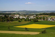
Thanks to the favourable climate and fertile grounds, the lower western plateau is the most important agricultural region of Switzerland.
Along the northern shores of the lakes of Geneva, Neuchâtel, Bienne, Morat, as well as in the Zürich Weinland and Klettgau, there is viticulture.
Grassland with dairy farming and beef production is predominant in the eastern plateau and in the higher regions.
The most important transversal, so to speak the backbone of the Swiss Plateau, is the A1 motorway that connects all the big cities going from Geneva over Lausanne, Bern, Zürich and Winterthur to St. Gallen.
The lakes also attract tourists, and then there are several spa towns, Baden, Schinznach-Bad, Yverdon-les-Bains and Zurzach, thanks to their hydrothermal vents.