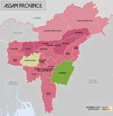
Sylhet Division
It is bordered by the Indian states of Meghalaya, Assam and Tripura to the north, east and south respectively, and by the divisions of Chittagong to the southwest and Dhaka and Mymensingh to the west.
However, Karimganj (including the thanas of Badarpur, Patharkandi and Ratabari) was inexplicably severed from Sylhet by the Radcliffe Boundary Commission.
[14] The later Hindu rajas of Sylhet, such as Gour Govinda, continued to pay tribute to the deity as Hāṭkeśvara or Haṭṭanātha as evident from the Devipurana and copper-plate inscriptions.
However, the district's Karimganj subdivision was given to India by Cyril Radcliffe, after apparently being pleaded by a delegation led by Abdul Matlib Mazumdar.
The link was established in 1988 when the St Albans District Council supported a housing project in Sylhet as part of the International Year of Shelter for the Homeless.
Numerous projects and businesses in the city and in large towns have been funded by Sylhetis living and working abroad.
[24] The Bangladesh government has set up a special Export Processing Zone (EPZ) in Sylhet, in order to attract foreign investors, mainly from the UK.
2022 Census Geographically the region is surrounded by hillocks (known as tillas) from all three sides except its western plain boundary with the rest of Bengal.
In the south of the region (Habiganj, Moulvibazar), eight hill ranges enter the plains of Sylhet running uniformly from the west to the east.
Its burgeoning economy has contributed to the regional attractions of landscapes filled with fragrant orange and pineapple gardens as well as tea plantations.
[28] The physiography of the division consists mainly of hill soils, encompassing a few large depressions known locally as "beels" which can be mainly classified as oxbow lakes, caused by tectonic subsidence primarily during the earthquake of 1762.
[27] Geologically, the division is complex having diverse sacrificial geomorphology; high topography of Plio-Miocene age such as the Khasi and Jaintia Hills and small hillocks along the border.
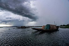
At the centre there is a vast low laying flood plain of recent origin with saucer shaped depressions, locally called haors.
[30] The Asian elephant were once found in small numbers in places such as Chapghat, Bhanugach, Chamtolla, Mahram and the Raghunandan hills.
The Adivasis and tea labourers brought over during the British colonial rule also have their own native languages such as Khasi, Kuki, Laiunghtor, Meitei, Bishnupriya Manipuri, Hajong, Garo, Odia, Kurmi creole, Hindi, Bhumij and Tripuri.
[32] Faujdar Farhad Khan built Sylhet Shahi Eidgah in the 1660s under the reign of Mughal Emperor Aurangzeb.
Nowka Bais is a common traditional rowing competition during the monsoon season when rivers are filled up, and much of the land is under water.
The tribal and Adivasi population tend to live in secluded rural areas of the region primarily near the hills and tea gardens.
They are made up of several ethnic groups such as the Bishnupriya Manipuris, Khasi, Lalengs, Tripuris, Meiteis, Garos, and Kukis.
[38] There are significant numbers of people who follow Sufi ideals similar to the Barelvis, the most influential is the teachings of Abdul Latif Chowdhury Fultali of Zakiganj – a descendant of one of the disciples of Shah Jalal.
[39] The revivalist Deobandi movement is also popular in the region with Jamia Tawakkulia Renga being a notable centre and many are part of the Tablighi Jamaat.
Places of procession include the Prithimpasha Nawab Bari in Kulaura, home to a royal Shia family, as well as Rajtila.
Hinduism is the second largest religion practised by the Bengali Hindus as well as majority of the Bishnupriya Manipuri, Beens, Bhumij, Bonaz, Sabar, Musahar, Kurmi, Lalengs, Bauris and Tripuri population.
[citation needed] This Gurdwara was visited twice by Tegh Bahadur and many hukamnamas were issued to this temple by Guru Gobind Singh.