Tachov
The historic town centre is well preserved and is protected by law as an urban monument zone.
The eastern and central parts of the municipal territory with the town proper lie in the Upper Palatine Forest Foothills.
The western part lies in the Upper Palatinate Forest and includes the highest point of Tachov, the hill Světecký vrch at 616 m (2,021 ft) above sea level.
King Ottokar II of Bohemia (1233–1278) built a new castle with a massive round stone tower there.
The Losy family began conversion of the medieval castle to a large baroque château.
The area was only partly repopulated, mostly by Czechs and Slovaks, but also by immigrants from Romania and Ukraine.
They gradually became a pride of Tachov, because they belong to the best-preserved wall systems in the country.
During World War II, the castle was used for civil and military purposes, but it was seriously ruined, so in 1968 there was the possibility of demolition.
Today, part of the building is used as a primary art school and the rest is open to the public.
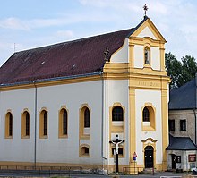
[11] The former Franciscan monastery and the Church of Saint Mary Magdalene were founded in 1466 and since this year both buildings went through many reconstructions.
The Italian architect Martino Allio made the first reconstruction in 1686–1694, and the most important one came in years 1745–1750.
Since 1945, the monastery has been used as the Museum of the Upper Palatinate Forest, and it offers information about the history of Tachov and the region surrounding it.
There is a 25 m (82 ft) high observation tower on its top[15] and a monument that commemorates the Battle of Tachov.