Geography of Taiwan
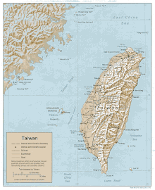
The island of Taiwan, formerly known to Westerners as Formosa, has an area of 35,808 square kilometres (13,826 sq mi) and makes up 99% of the land under ROC control.
The ROC also controls a number of smaller islands, including the Penghu archipelago in the Taiwan Strait, Kinmen and Matsu in Fuchien near the PRC's coast, as well as Pratas and Taiping in the South China Sea.
Geologically, the main island comprises a tilted fault block, characterized by the contrast between the eastern two-thirds, consisting mostly of five rugged mountain ranges running parallel to the east coast, and the flat to gently rolling plains of the western third, where the majority of the population resides.
Several peaks exceed 3,500 m in height - the highest, Yu Shan at 3,952 m (12,966 ft), makes Taiwan the world's fourth-highest island.
The heavily forested eastern mountains provide a habitat for a diverse range of wildlife, while human land use in the western and northern lowlands is intensive.
The islands of Kinmen and Matsu near the coast of Fujian across the Taiwan Strait have a total area of 180 km2 (69 sq mi);[10] the Pratas and Taiping islets in the South China Sea are also administered by the ROC, but are not part of the Taiwanese archipelago.
[13] The western part of the island, and much of the central range, consists of sedimentary deposits scraped from the descending edge of the Eurasian Plate.
[19] The terrain in Taiwan is divided into two parts: the flat to gently rolling plains in the west, where 90% of the population lives, and the mostly rugged forest-covered mountains in the eastern two-thirds.
The mountains are predominantly composed of hard rock formations resistant to weathering and erosion, although heavy rainfall has deeply scarred the sides with gorges and sharp valleys.
Taroko National Park, on the steep eastern side of the range, has good examples of mountainous terrain, gorges and erosion caused by a swiftly flowing river.
Badlands are located at the western foot of the range, where the ground water level is the lowest and rock formations are the least resistant to weathering.
Raised coral reefs along the east coast and the frequent occurrences of earthquakes in the rift valley indicate that the fault block is still rising.
About 23% of Taiwan's land area consists of fertile alluvial plains and basins watered by rivers running from the eastern mountains.
[30] Most of the plains and low-lying hills of the west and north of the island have been cleared for agricultural use since the arrival of the Chinese immigrants during the 17th and 18th century.
However the mountain forests are very diverse, with several endemic species such as Formosan cypress (Chamaecyparis formosensis) and Taiwan fir (Abies kawakamii), while the camphor laurel (Cinnamomum camphora) was once also widespread at lower altitudes.
Before the country's industrialization, the mountainous areas held several endemic animal species and subspecies, such as the Swinhoe's pheasant (Lophura swinhoii), Taiwan blue magpie (Urocissa caerulea), the Formosan sika deer (Cervus nippon taiwanensis or Cervus nippon taiouanus) and the Formosan landlocked salmon (Oncorhynchus masou formosanus).
[31] Taiwan had relatively few carnivores, 11 species in total, of which the Formosan clouded leopard is likely extinct and the otter is restricted to Kinmen island.
Kenting National Park on the southern tip of Taiwan contains uplifted coral reefs, moist tropical forest and marine ecosystems.
Yushan National Park has alpine terrain, mountain ecology, forest types that vary with altitude, and remains of ancient roads.
Because of the intensive exploitation throughout Taiwan's pre-modern and modern history, the island's mineral resources (e.g. coal, gold, marble), as well as wild animal reserves (e.g. deer), have been virtually exhausted.
Consequently, upon the decline of subsistence, Taiwan's agriculture now relies heavily on the marketing and export of specialty crops, such as bananas, guavas, lychees, bell fruits, and high-mountain tea.
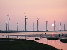
[39] Nearly all oil and gas for transportation and power needs must be imported, making Taiwan particularly sensitive to fluctuations in energy prices.
[citation needed] Taiwan has a population of over 23 million, the vast majority of whom live in the lowlands near the western coast of the island.
The most notable areas are the southern suburbs of Taipei and the western stretch from Tainan to Lin Yuan, south of Kaohsiung.
[48] Motor scooters, especially older or cheaper two-stroke versions, which are ubiquitous in Taiwan, contribute disproportionately to urban air pollution.
[1] Though regulation of sulfate aerosol emissions from petroleum combustion is becoming stringent, acid rain remains a threat to the health of residents and forests.
[53] Illegal extraction by Chinese sand dredging vessels has caused significant damage to the marine environment of Taiwan's outlying areas.