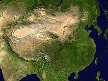
Tarim Basin
Bachu or Miralbachi; Uchturpan north of the main road; Aksu on the large Aksu River; Kucha was once an important kingdom; Luntai; Korla, now a large town; Karashar near Bosten Lake; Turpan north of the Turpan Depression and south of the Bogda Shan; Hami; then southeast to Anxi and the Gansu Corridor.
Settlements include Kashgar; Yangi Hissar, famous for its knives; Yarkand, once larger than Kashgar; Karghalik (Yecheng), with a route to India; Karakash; Khotan, the main source of Chinese jade; eastward the land becomes more desolate; Keriya (Yutian); Niya (Minfeng); Qiemo (Cherchen); Charkilik (Ruoqiang).
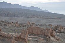
There is currently no road east across the Kumtag Desert to Dunhuang, but caravans somehow made the crossing through the Yangguan pass south of the Jade Gate.
The Tarim Basin is the result of an amalgamation between an ancient microcontinent and the growing Eurasian continent during the Carboniferous to Permian periods, a process which ended in the earliest Triassic with the closure of the Palaeo-Asian Ocean.
The source rocks of oil and gas tend to be mostly Permian mudstones and, less often, Ordovician strata which experienced an intense and widespread early Hercynian karstification.
[9] Below the level enriched with gas and oil is a complex Precambrian basement believed to be made up of the remnants of the original Tarim microplate, which accrued to the growing Eurasian continent in Carboniferous time.
[11] China National Petroleum Corporation's comprehensive exploration of the Tarim basin between 1989 and 1995 led to the identification of 26 oil- and gas-bearing structures.
[12] On June 10, 2010, Baker Hughes announced an agreement to work with PetroChina Tarim Oilfield Co. to supply oilfield services, including both directional and vertical drilling systems, formation evaluation services, completion systems and artificial lift technology for wells drilled into foothills formations greater than 7,500 meters (24,600 feet) deep with pressures greater than 20,000 psi (1,400 bar) and bottom-hole temperatures of approximately 160 °C (320 °F).
[16]: p.343 Structures made of mud bricks were found at Xintala, showing building techniques similar to those seen in early oasis sites in western Central Asia, as well as in Yanbulake.
[16]: p.344 Autosomal genetic evidence suggests that the earliest Tarim people arose from locals of primarily Ancient North Eurasian descent with significant Northeast Asian admixture.
[17] In the Iron Age, the Chawuhu culture (c. 1000–400 BC) flourished in the Yanqi (Karashar) oasis, and also reached the Alagou sites near the Turfan basin, and north to the region close to Ürümqi.
[16]: p.348 Earlier diggings in the southern Tarim Basin, in the 1990s, suggested that Yuansha (Djoumbulak Koum) in the Keriya river valley was the earliest fortified urban site, from around 400 BC, but new surveys and excavations between 2018 and 2020, showed that the site Kuiyukexiehai'er (Koyuk Shahri), located in the northern Tarim Basin, is actually the earliest fortified urban settlement in the entire region, covering 6 hectares, and developed in four phases between c. 770 BC and 80 AD.
Spouted jars were found at this site, similar to those of Chawuhu culture, and buckles and moulds with animal motifs resemble steppe traditions.
In the Achaemenid era Old Persian inscriptions found at Persepolis, dated to the reign of Darius I (r. 522–486 BC), the Saka are said to have lived just beyond the borders of Sogdiana.
[24] A people believed to be Saka has also been found in various locations in the Tarim Basin, for example in the Keriya region at Yumulak Kum (Djoumboulak Koum, Yuansha) around 200 km east of Khotan, with a tomb dated to as early as the 7th century BC.
[25][26] According to the Sima Qian's Shiji, the nomadic Indo-European Yuezhi originally lived between Tengri Tagh (Tian Shan) and Dunhuang in Gansu, China.
[24]: 13–14 Whereas the Yuezhi continued westward and conquered Daxia around 177–176 BC, the Sai (i.e. Saka), including some allied Tocharian peoples, fled south to the Pamirs before heading back east to settle in Tarim Basin sites like Yanqi (焉耆, Karasahr) and Qiuci (龜茲, Kucha).
The Han Chinese wrested control of the Tarim Basin from the Xiongnu at the end of the 1st century under the leadership of General Ban Chao (32–102 CE), during the Han-Xiongnu War.
[39] During the Tang dynasty, a series of military expeditions were conducted against the oasis states of the Tarim Basin, then vassals of the Western Turkic Khaganate.
[42] The expansion into Central Asia continued under Taizong's successor, Emperor Gaozong, who dispatched an army in 657 led by Su Dingfang against the Western Turk qaghan Ashina Helu.
[58] In the tenth century, the Karluks, Yagmas, Chigils and other Turkic tribes founded the Kara-Khanid Khanate in Semirechye, Western Tian Shan, and Kashgaria.
[62][63] Accounts of the Muslim Karakhanid war against the Khotanese Buddhists are given in Taẕkirah of the Four Sacrificed Imams written sometime in the period from 1700 to 1849 which told the story of four imams from Mada'in city (possibly in modern-day Iraq) who traveled to help the Islamic conquest of Khotan, Yarkand, and Kashgar by Yusuf Qadir Khan, the Karakhanid leader.
[73] By the early 17th century, the Naqshbandi Sufi Khojas, descendants of Muhammad, had replaced the Chagatayid Khans as rulers of the Tarim Basin.
[75][76][77][78] Dzungharia or Ili was called Zhunbu 準部 (Dzungar region) Tianshan Beilu 天山北路 (Northern March), "Xinjiang" 新疆 (New Frontier),[79] or "Kalmykia" (La Kalmouquie in French).
The Tarim Basin was known as "Tianshan Nanlu 天山南路 (southern March), Huibu 回部 (Muslim region), Huijiang 回疆 (Muslim frontier), Chinese Turkestan, Kashgaria, Little Bukharia, East Turkestan", and the traditional Uyghur name for it was Altishahr (Uyghur: التى شهر, romanized: Altä-shähär, Алтә-шәһәр).
There are also smaller numbers of Hui and other ethnic groups, for example, the Tajiks who are concentrated at Tashkurgan in the Kashgar Prefecture, the Kyrgyz in Kizilsu, and the Mongols in Bayingolin.
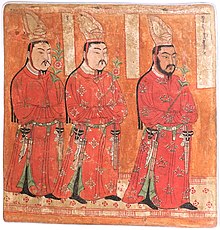
[86] The mummies have been described as being both "Caucasoid" and "Mongoloid" and mixed-race individuals are also observed,[87] and genetics analysis also indicate that the population was of mixed ancestry in the bronze and iron age periods.
This research led to significant findings; remains of hamlets with wattle and daub structures as well as farm land, orchards, vineyards, irrigation pools and bridges.
The texts are legal documents such as tax lists, and contracts containing detailed information pertaining to the administration of daily affairs.
[90] Additional excavations have unearthed tombs with mummies,[91] tools, ceramic works, painted pottery and other artistic artifacts.


Obv: Kharosthi legend, "Of the great king of kings, king of Khotan, Gurgamoya.
Rev: Chinese legend: "Twenty-four grain copper coin". British Museum