Taupō Volcanic Zone
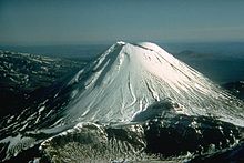
Mount Ruapehu marks its south-western end and the zone runs north-eastward through the Taupō and Rotorua areas and offshore into the Bay of Plenty.
It is part of a larger Central Volcanic Region that extends to the Coromandel Peninsula and has been active for four million years.
[6] It is believed to have first emptied the lake, then followed that feat with a pyroclastic flow that covered about 20,000 km2 (7,700 sq mi) of land with volcanic ash.
It has been suggested that this was the cause of the tsunami tens of metres tall that went up to 7 kilometres (4.3 mi) inland in the Bay of Plenty at about this time.
Mount Ruapehu marks its southwestern end, while Whakaari / White Island is considered its northeastern limit.
[11] It forms a southern portion of the active Lau-Havre-Taupō back-arc basin, which lies behind the Kermadec-Tonga Subduction Zone.
Mayor Island / Tūhua is the northern-most shield volcano adjacent to the New Zealand coast, and is believed to have been active in the last 1000 years.
[23] Further the distinctive Waiteariki ignimbrite that erupted 2.1 million years ago in a supereruption, presumably from the gravity anomaly defined Omanawa Caldera,[24] is within the postulated borders of the old Taupō Rift.
It can not be assumed that just because the rate of expansion of the rift is greatest near the coast that this is where most significant tectonic earthquakes in terms of human risk will be.
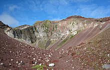
The north (Whakatane Graben – Bay of Plenty) part of the zone is predominantly formed from andesitic magma[26][27] and represented by the continuously active Whakaari / White Island andesite–dacite stratovolcano.
These have resulted from massive infrequent eruptions of gaseous very viscous rhyolite magma which is rich in silicon, potassium, and sodium and created the ignimbrite sheets of the North Island Volcanic Plateau.
[35] This central zone has had the largest number of very large silicic caldera-forming eruptions recently on earth as mentioned earlier.
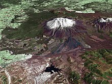
[37] Mount Tauhara adjacent to Lake Taupō is actually a dacitic dome [38] and so intermediate in composition between andesite and rhyolite but still more viscous than basalt which is rarely found in the zone.
[42] Earthquakes can be associated with landslides and inland or coastal tsunami that can result in great loss of life and both have happened on the Waihi Fault Zone.
[43] The relative low grade volcanic activity of the andesite volcanoes at each end of the zone has resulted in recorded history in both direct loss of life and disrupted transport and tourism.
The only high grade eruption in recorded history was atypically basaltic from Mount Tarawera and although very destructive is not likely to be a perfect model for the more typical and often larger rhyolitic events associated with the Taupō Volcano and the Ōkataina Caldera.
[44] These eruptions are associated with tephra production that results in deep ash fall over wide areas (e.g. the Whakatane eruption of ~ 5500 years ago had 5 mm (0.20 in) ashfall 900 km (560 mi) away on the Chatham Islands) `[45] pyroclastic flows and surges, which rarely have covered large areas of the North Island in ignimbrite sheets, earthquakes, lake tsunamis, prolonged lava dome growth and associated block and ash flows with post-eruption lahars and flooding.