Geology of New Zealand
New Zealand is part of Zealandia, a microcontinent nearly half the size of Australia that broke away from the Gondwanan supercontinent about 83 million years ago.
[1] New Zealand's early separation from other landmasses and subsequent evolution have created a unique fossil record and modern ecology.
[4] The provinces are further divided into terranes – large slices of crust with different geological histories that have been brought together by tectonic activity (subduction and strike-slip faulting) to form New Zealand.
[6] These rocks form the foundations beneath offshore Taranaki, and much of the West Coast, Buller, north-west Nelson, Fiordland and Stewart Island / Rakiura.
Many rocks in the Eastern Province have been metamorphosed into the Haast Schist, due to exposure to high pressures and temperatures.
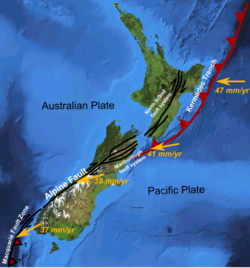
The Alpine Fault that corresponds to the line of the Southern Alps has separated the basement rocks that used to be adjacent by about 480 km.
Dinosaurs continued to live in New Zealand after it separated from Gondwana, as shown by sauropod footprints from 70 million years ago in Nelson.
Neither marsupials nor placental mammals evolved and reached Australia in time to be on New Zealand when it drifted away 85 million years ago.
The convergent part of the plate boundary propagated through Zealandia from the north, eventually forming a proto-Alpine Fault in Miocene times (23 Ma).
In the South Island, limestone is present in Buller, Nelson, and the West Coast, including the Pancake Rocks at Punakaiki in Oligocene–Early Miocene times (34–15 Ma).
It is debated whether all of New Zealand was submerged at this time or if small islands remained as "arks" preserving fauna and flora.
Layers of rocks were peeled off the higher land, from the top down, and slid southwest under the influence of gravity, to be stacked the right way up, but in reverse order.
However, in the late Cretaceous (100–65 Ma), there was widespread volcanic activity in Marlborough, West Coast, Canterbury and Otago which contributes to landforms such as Mount Somers.
Shortly after (18 Ma), a volcanic arc developed further east to create the Coromandel Ranges and undersea Colville Ridge.
In the Kauaeranga Valley, volcanic plugs remain, as does a lava lake that now forms the top of Table Mountain.
The Tongariro Volcanic Centre is composed of andesitic volcanoes, while the areas around Taupō and Rotorua are largely rhyolitic with minor basalt.
This includes vast pumice deposits generated from eruptions in the Taupō Volcanic Zone occur throughout the central North Island, Bay of Plenty, Waikato, King Country and Manawatū-Whanganui regions.
Whakaari / White Island, in the Bay of Plenty, represents the southern end of this chain and is a very active andesitic volcano, erupting with great frequency.
Notable geothermal areas include Whakarewarewa, Tikitere, Waimangu, Waiotapu, Craters of the Moon and Orakei Korako.
The East Coast of the South Island is sliding obliquely towards the Alpine Fault, relative to Westland, causing the Southern Alps to rise about 10 mm/yr (although they are also worn down at a similar rate).
Shallow earthquakes are more widespread, occurring almost everywhere throughout New Zealand (especially the Bay of Plenty, East Cape to Marlborough, and Alpine Fault).
In the Miocene there are paleontological records of warm lakes in Central Otago with palm trees and small land mammals.
The land north of Hamilton was forested, but much of the rest of New Zealand was covered in grass or shrubs, due to the cold and dry climate.
[32][33] This lack of vegetation cover lead to greater wind erosion and the deposition of loess (windblown dust).
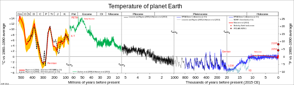
The key facts to emerge are that New Zealand did experience a noticeable cooler climate, but at a slightly later date than in the Northern Hemisphere.
Groundwater reservoirs are extracted throughout the country, but are particularly valuable in the dryer eastern regions of both the North and South Islands.
Patrick Marshall coined the terms andesite line and ignimbrite in the early 1900s while working in the Taupō Volcanic Zone.
[44] Charles Cotton became an international authority on geomorphology using New Zealand active tectonics and variable climate to create universally applicably rules.
[46] Charles Fleming established the Wanganui Basin as a classic site for studying past sea levels and climates.
[49] The universities of Auckland, Canterbury, Massey, Otago, Victoria and Waikato are activity engaged in geological research in New Zealand, Antarctica, the wider South Pacific and elsewhere.


Source: Institute of Geological and Nuclear Sciences , New Zealand