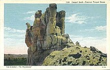
Teapot Rock
It is located a few hundred yards east of Wyoming Highway 259, about 19 miles (30 km) north of Casper, Wyoming in the Powder River Basin near Teapot Creek, a tributary of Salt Creek.
[2] The outline of the rock once resembled a teapot and gave its name to several man-made and natural features, including a geologic structural uplift known as the Teapot Dome, and an oil field about 6 miles (10 km) east.
[1] Over time, the features that gave the formation its name have been eroded by windstorms; the "handle" disappeared in 1930 and the "spout" in 1962.
[3] In 1915, the Teapot Dome Oil Field was designated Naval Petroleum Reserve Number Three as part of a program to ensure that the U.S. Navy, which was converting to oil-fired boilers, would have sufficient fuel reserves in an emergency.
This article about a property in Wyoming on the National Register of Historic Places is a stub.