Mount Bromo
The area is one of the most visited tourist destinations in East Java, and the volcano is included in the Bromo Tengger Semeru National Park.
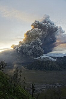
[2] Mount Bromo is located in the middle of a plain called "Sea of Sand" (Javanese: Segara Wedi or Indonesian: Lautan Pasir), a nature reserve that has been protected since 1919.
Depending on the level of volcanic activity, the Indonesian Center for Volcanology and Disaster Mitigation sometimes issues a warning not to visit Mount Bromo.
As a precaution, local residents and tourists were instructed to remain clear of an area within a radius of three kilometers from the caldera and refugee encampments were erected.
[5] On 29 November 2010, Transport Ministry spokesman Bambang Ervan announced that Malang's domestic airport would be closed until 4 December 2010.
Continuous eruptions on 21 January caused a thin ash fall mainly in the village areas of Ngadirejo and Sukapura Wonokerto in Probolinggo Regency.
Airport official Sherly Yunita was reported at the time as stating that concerns about visibility had prompted Singapore Airlines, Jetstar-ValueAir, Air France-KLM, Virgin Blue and Cathay Pacific to cancel several flights to Bali, 340 km (211 mi) to the east.
They indicated that ash was observed at altitudes up to 18,000 feet (5,486 m) (FL180) extending 200 nautical miles (370 km; 230 mi) to the south east of the caldera.
[7] Mount Bromo showed signs of increasing activity beginning in 4th Dec 2015, when the amount of smoke coming out of the crater intensified.
[13] Indonesian Volcano Monitoring Bureau (PVBMG) issued a warning that forbade people from climbing Mount Bromo.
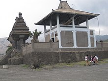
The temple holds a significant importance to the Tenggerese scattered across the mountain villages, such as Ngadisari, Wonokitri, Ngadas, Argosari, Ranu Prani, Ledok Ombo and Wonokerso.
Pura Luhur Poten uses natural black stones from volcanoes nearby, while Balinese temples are mostly made from red bricks.