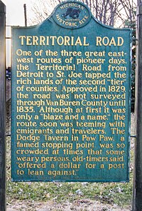
Territorial Road (Michigan)
[3] Starting at Michigan Avenue (modern-day US Highway 12) in downtown Detroit, it generally parallels the present-day Interstate 94.
[2] Generally, Michigan's main highways followed trails used by Native Americans for centuries to travel between their villages and hunting and fishing grounds.
[5] The trails were narrow paths, about 12 to 18 inches (300 to 460 mm) wide, located on high, dry ground along streams and watersheds.
[4] Initially, branches and bushes were cleared, making the trails two to three feet wide to allow room for pack horses.
[4] Federal funds were appropriated to improve the roads, which involved cutting down trees and filling in swampy and low areas.
The road began at Sheldon Inn at the corner of what is now Michigan Avenue and Geddes Road (named for Washtenaw County settlers Robert and John Geddes) and ended at its western-most point at the mouth of the St. Joseph River at Lake Michigan.
[8] The federal government provided $20,000 (equivalent to $652,000 in 2023[9]) to upgrade and complete the road,[7] to accommodate the weight of settler's wagons.